US7606579B2 - Auto mapping through location based triggers - Google Patents
Auto mapping through location based triggers Download PDFInfo
- Publication number
- US7606579B2 US7606579B2 US11/164,683 US16468305A US7606579B2 US 7606579 B2 US7606579 B2 US 7606579B2 US 16468305 A US16468305 A US 16468305A US 7606579 B2 US7606579 B2 US 7606579B2
- Authority
- US
- United States
- Prior art keywords
- mobile device
- mapping
- information
- zone
- control system
- Prior art date
- Legal status (The legal status is an assumption and is not a legal conclusion. Google has not performed a legal analysis and makes no representation as to the accuracy of the status listed.)
- Expired - Fee Related, expires
Links
Images


Classifications
-
- G—PHYSICS
- G01—MEASURING; TESTING
- G01C—MEASURING DISTANCES, LEVELS OR BEARINGS; SURVEYING; NAVIGATION; GYROSCOPIC INSTRUMENTS; PHOTOGRAMMETRY OR VIDEOGRAMMETRY
- G01C21/00—Navigation; Navigational instruments not provided for in groups G01C1/00 - G01C19/00
- G01C21/26—Navigation; Navigational instruments not provided for in groups G01C1/00 - G01C19/00 specially adapted for navigation in a road network
- G01C21/28—Navigation; Navigational instruments not provided for in groups G01C1/00 - G01C19/00 specially adapted for navigation in a road network with correlation of data from several navigational instruments
- G01C21/30—Map- or contour-matching
-
- G—PHYSICS
- G01—MEASURING; TESTING
- G01S—RADIO DIRECTION-FINDING; RADIO NAVIGATION; DETERMINING DISTANCE OR VELOCITY BY USE OF RADIO WAVES; LOCATING OR PRESENCE-DETECTING BY USE OF THE REFLECTION OR RERADIATION OF RADIO WAVES; ANALOGOUS ARRANGEMENTS USING OTHER WAVES
- G01S5/00—Position-fixing by co-ordinating two or more direction or position line determinations; Position-fixing by co-ordinating two or more distance determinations
- G01S5/0009—Transmission of position information to remote stations
- G01S5/0018—Transmission from mobile station to base station
- G01S5/0027—Transmission from mobile station to base station of actual mobile position, i.e. position determined on mobile
-
- G—PHYSICS
- G01—MEASURING; TESTING
- G01S—RADIO DIRECTION-FINDING; RADIO NAVIGATION; DETERMINING DISTANCE OR VELOCITY BY USE OF RADIO WAVES; LOCATING OR PRESENCE-DETECTING BY USE OF THE REFLECTION OR RERADIATION OF RADIO WAVES; ANALOGOUS ARRANGEMENTS USING OTHER WAVES
- G01S19/00—Satellite radio beacon positioning systems; Determining position, velocity or attitude using signals transmitted by such systems
- G01S19/01—Satellite radio beacon positioning systems transmitting time-stamped messages, e.g. GPS [Global Positioning System], GLONASS [Global Orbiting Navigation Satellite System] or GALILEO
- G01S19/13—Receivers
- G01S19/14—Receivers specially adapted for specific applications
-
- H—ELECTRICITY
- H04—ELECTRIC COMMUNICATION TECHNIQUE
- H04W—WIRELESS COMMUNICATION NETWORKS
- H04W60/00—Affiliation to network, e.g. registration; Terminating affiliation with the network, e.g. de-registration
- H04W60/02—Affiliation to network, e.g. registration; Terminating affiliation with the network, e.g. de-registration by periodical registration
Definitions
- This invention is related to the fields of geocentric location devices and systems, and distributed geocentric location based systems and their application to cartography and, more particularly to utilizing geocentric location based systems to map out un-charted or modified topographies and utilizing the created mappings within a navigation system.
- NGA National Geospatial-Intelligence Agency
- NIMA National Imagery and Mapping Agency
- mapping information we continuously are changing the face of planet Earth.
- an outdated atlas or map will pose absolutely no problems.
- An example of such an industry is the construction industry, as well as the various industries that operate in and around new construction sites.
- GPS Global Positioning System
- GPS technology includes multiple geostationary satellite systems that provide location and timing signals to earth bound GPS receivers. Such technology can greatly improve the ability for companies to keep track of their assets or mobile forces.
- the above-listed related patent application is directed towards exploiting the technology developments in location identification technology and wireless communications to help improve the efficiency of a deployed work force oriented business.
- it discloses a system to identify the location of a company's deployed assets and provide the deployed asset with work order information relevant to a job tied to the identified location or a particular piece of equipment at that location.
- the above-listed related patent application discloses an automated dispatcher capability that can track deployed forces, automatically adjust work orders to more efficiently service customers, collect and provide current status and information for various projects in a real-time manner, and provide status relevant information to field workers based on measurements and status information obtained from the field.
- an unmapped area such as a new construction territory, in which roads, addresses and other mapping information is not available can be problematic.
- mapping information can be utilized to supplement mapping information within navigation systems, such as in-vehicle navigation systems.
- the present invention addresses the above-identified needs in the art, as well as other needs in the art through providing a system that relies on a plurality of mobile units that communicate with a centralized system and provides geocentric information about an uncharted or an active mapping region and, utilizing such geocentric information to create maps for the active mapping region.
- the mobile units include technology that enables the mobile devices to identify their physical location at any particular time, and wireless communication technology to enable constant communication with the control system that, among other things, operates a map creation application. In operation, mobile devices are deployed along with the work forces for a particular company but could also be dedicated units that are mobilized solely for the purpose of creating maps.
- the present invention includes a system for updating and creating mapping information for an active mapping region.
- the system includes two primary components: a control system and one or more mobile devices.
- Each of the mobile devices includes a GPS receiver and a radio transceiver.
- the mobile devices communicate with the control system through the radio transceiver.
- the mobile devices periodically obtain a current location reading from the GPS receiver and then transmit the current location reading to the control system.
- the control system receives the current location reading from a mobile device and determines if the current location reading falls within an active mapping zone. If the current location reading is within in active mapping zone, the control system begins updating the mapping information using the last reading and subsequent location readings from the mobile device.
- control system may request the mobile device to increase the frequency at which the location readings are provided. This aspect of the invention increases the granularity of detail in the mapping information. Once the location reading falls outside of the active mapping region, the control system requests the mobile device to revert to normal reporting mode and commences with normal operation.
- mapping information that can be loaded into a navigational system, such as an in-vehicle navigational system, to supplement the commercially available or standard mapping information embedded within the navigational system.
- this aspect of the present invention allows for navigational systems to be updated with current mapping information as changes are made within uncharted or active mapping regions.
- the new mapping information is either used instead of the previously loaded mapping information, or is overlaid on the previous mapping information.
- FIG. 1 is a system diagram of the various components and devices of an exemplary system that could be utilized to implement embodiments of the present invention.
- FIG. 2 is a block diagram of an exemplary mobile device suitable for embodiments of the present invention.
- FIG. 3A is a screen shot of a mapping application that is displaying a map that includes a mapped region and an unmapped region.
- FIG. 3B is a screen shot of a mapping application that is displaying a map and showing a vehicle or mobile device approaching the unmapped region along a previously mapped road.
- FIG. 3C is a screen shot of a mapping application that is displaying a map and showing vehicle from FIG. 3B entering into the unmapped region at a particular point and then continuing along previously mapped road in the unmapped region.
- FIG. 3D is a screen shot of a mapping application that is displaying an enlarged view of the unmapped region of FIG. 3C .
- FIG. 3E is a screen shot of a mapping application that is displaying a map and showing the vehicle from FIGS. 3B-3C turning off of the previously mapped road.
- FIG. 3F is a screen shot of a mapping application that is displaying a map and showing additional turns and roads that are added into the map of the unmapped region.
- FIG. 3G is a screen shot of a mapping application that is displaying a map and showing an updated version of the new map for the unmapped region that is downloaded to subsequent visitors to the unmapped region.
- FIG. 4 is a flow diagram summarizing the operation of an exemplary embodiment of the present invention.
- FIG. 5 is a state diagram illustrating the operation of an embodiment of the utilization of the mapping information within a navigational system aspect of the present invention.
- the present invention operates to create updated mapping information for new construction areas, but can also be employed in creating mapping information for any uncharted area, as well as simply verifying, augmenting or updating mapping information for any area.
- work forces that are deployed within an area to be mapped are equipped with location identification equipment, such as a GPS receiver, and optionally, with wireless data communication equipment.
- FIG. 1 is a system diagram of the various components and devices of an exemplary system that could be utilized to implement embodiments of the present invention.
- the system 100 includes various components that are communicatively coupled to each other using various communication techniques.
- a geostationary orbiting satellite positioning system 110 operates to provide signals to mobile devices 141 , 142 and 143 . These satellite signals can be used by the mobile devices to identify the location of the mobile devices.
- the operation of such a typical geostationary orbiting satellite positioning system is well known to those skilled in the art.
- the most common satellite system that operates to provide such information is the Global Positioning System or GPS.
- the GPS is a constellation of twenty-four well-spaced satellites that orbit the Earth at 10,600 miles above sea level.
- the satellites are spaced at such intervals and altitude that for any given point on the Earth, at least four satellites will be communicatively seeable, or above the horizon.
- Each satellite in the GPS constellation includes a computer system, an atomic clock, and a transmitter.
- the satellites continuously transmit a data stream that identifies the current position of the satellite and the current time.
- the mobile units are able to identify the longitudinal and latitudinal coordinates at which the mobile device is located.
- the present invention is not limited to operation with the GPS and other location technologies can also be utilized.
- GPS is used within the context of this description, it is synonymous with other compatible location determining technologies unless otherwise stated.
- the mobile devices 141 , 142 and 143 are equipped to receive and/or determine location information, and also to transmit information to a dispatch and control or central system 130 through a communications medium.
- the communications medium is a cellular telephone network utilizing technology such as GSM with GPRS, CDMA, TDMA, or similarly capable technologies. This technology enables the communication of data between the mobile devices and the control system.
- the cellular based data transmissions from the mobile devices 141 , 142 and 143 are received by the mobile system 190 at antenna 192 and are provided to the mobile switching center 194 .
- the mobile switching center then provides the received data transmissions to the control system 130 through a data network 180 .
- the control system 130 is also functional to transmit data to the mobile devices 141 , 142 and 143 through the data network 180 and the cellular system 190 .
- the control system 130 includes a database system 120 that houses, among other things, data utilized for various embodiments of the present invention.
- the mobile devices 141 and 142 are shown as including a display and a key pad. Such elements can be included in various embodiments of the present invention in addressing various aspects and functions of the invention and allow a user of the mobile device to review information received from the GPS transmitters and the control system, and to enter additional information to be provided back to the control system 130 . However, it will be appreciated that other embodiments may not require such elements.
- the mobile device 143 is shown as interfacing to an external display device or an external device 144 that includes a display, such as a navigational system.
- the control system can provide data to the external device 144 through the mobile device 143 , or in other embodiments may directly provide data to the external device 144 .
- the mobile devices may also interface to other data devices such as scanners, digital cameras, audio devices, analog to digital converters, an automobile data bus, measurement equipment, digital clocks, or other various devices.
- the control system 130 includes the database system 120 .
- the database system 120 can contain a variety of information depending on the various embodiments of the present invention.
- the database system 120 and the control system 130 may also be accessed via computer 185 .
- Such a system allows the information in the database and information regarding the various mobile devices to be accessed from any computer system connected to the control system 130 through the data network 180 .
- FIG. 1 describes an exemplary environment that is suitable for the present invention, the present invention is equally applicable to other environments and is not limited to the illustrated environment. Rather, the illustrated environment has been provided as a non-limiting example of the operation of the present invention.
- FIG. 2 is a block diagram of an exemplary mobile device suitable for embodiments of the present invention.
- the mobile device 141 is shown as an all-in-one self-contained box that includes various external connectors. Having all of the functional components within a single box allows for rapid and ease of installation but is not a requirement of the present invention.
- the mobile device can be constructed to be small and lightweight for easy transportation.
- the overall operation of the mobile device 141 is controlled by a processing unit 210 that includes memory element 212 for housing the software or firmware for defining the operation of the device, as well as temporary variables and status indicators.
- the mobile device 141 includes a GPS receiver 220 and a radio transceiver (transmitter and receiver) 230 .
- the GPS receiver 220 can be enabled to detect signals from the GPS satellites and determine the location of the mobile device 141 . The location information is then provided to the processing unit 210 for storage in memory 212 or for immediate transmission through radio transceiver 230 .
- the processing unit 210 can interface to various input and/or output devices through an interface unit 240 .
- the processor can receive key actuations from optional keypad 250 and display status or other information on optional display 252 .
- the processing unit 210 can interface to external devices 260 , measurement equipment, analog inputs, digital inputs or instrumentation through the interface unit 240 .
- a measurement device may provide a digital or analog signal to the processing unit for storage, processing or otherwise acting upon.
- mapping information that can be loaded into a navigational system, such as an in-vehicle navigational system, to supplement the commercially available or standard mapping information embedded within the navigational system.
- External equipment 260 can be such a navigational system and as such, receive updated mapping system through the mobile device 141 .
- the mobile device 141 may be embedded within, or also operate as a navigational system.
- the processing unit 210 may also receive information through the radio transceiver 220 such as status, data and operational commands.
- the mobile device 141 may receive a request from the control system 130 to provide the current location of the mobile device 141 .
- the processing unit enables the GPS receiver 220 to decode the current location. This information is then transmitted to the control system 130 .
- the general scope of the present invention is to provide a real-time or near real-time gathering of data to accumulate mapping information in new areas or rapidly changing areas, such as construction zones.
- One aspect of the present invention is the automatic detection of entering into a non-mapped zone and automatically generating mapping information for the zone.
- Another aspect of the present invention is detecting the entry into a non-mapped zone or a partially mapped zone and providing current mapping information.
- Another aspect of the present invention is augmenting partially mapped zones with additional information as subsequent information is received from participants entering the area.
- the interrupts, or more aptly termed, triggers, that are associated with this aspect of the present invention and invoke communication from the various mobile devices fall into two categories: (a) triggers initiated by the mobile device receiving GPS or location information and (b) triggers initiated by operation of the mobile device or a peripheral to the mobile device or operator initiated triggers.
- triggers initiated by the mobile device receiving GPS or location information and (b) triggers initiated by operation of the mobile device or a peripheral to the mobile device or operator initiated triggers.
- the details of these triggers are more thoroughly described in the above-referenced patent application which is incorporated herein by reference and thus, will not be fully described herein.
- the mobile device based triggers are described within the context of this specification in that they are the most obviously related to the present invention.
- the mobile device initiated triggers can be generated from a variety of circumstances. For instance, each time the mobile unit 141 is moved (which can be detected through the GPS receiver 220 ), the mobile device 141 may trigger an alert to the control system 130 .
- the control system 130 may load location parameters into the mobile device 141 through a radio transmission to the radio transceiver 230 . These parameters can define alert zones. If the mobile device 141 enters into or approaches one of the alert zones (or exits an alert zone) the mobile device 141 can transmit a message to the control system 130 .
- This aspect of the present invention can be used to notify the control system 130 as to the current location of the mobile device 141 , the transportation routes of the mobile device 141 and when the mobile device 141 is in an area that requires attention.
- FIGS. 3A-3G are screen shots of a GUI in different states for an exemplary embodiment of the present invention operating on control system 130 .
- FIG. 3A shows a screen shot 300 that includes a mapped region 310 and an unmapped region 320 .
- the mapped region 310 is an area that mapping information is available for, and can be obtained from one or more sources either through a purchase or for free. In addition, such information can be included in the purchase of other systems such as a GPS location system.
- the unmapped region 320 is an area in which either commercially available mapping information is not available or, currently available mapping information is inaccurate due to previous changes or pending changes in the topography of the region.
- mapping information may be readily available for a large farming area but, if that farming area is being developed into a rural neighborhood, then the mapping information will require changing.
- the unmapped region 320 several roads are identified; however, there is an area that does not include any roads or landmarks. Such an area could be undeveloped land or farm land.
- an administrator of the system can create a geo-fence that defines the boarder of the unmapped region 320 .
- the control system 130 (or the host computer) creates a new map of the geo-fenced area and the host system will then continually update this map with new data that is provided to the host system 130 . When a vehicle or work force entity enters into this region, the host system 130 will send the latest version of this map to the mobile device.
- FIG. 3B shows a vehicle or mobile device approaching the unmapped region 320 along road 330 . While operating in this region, the mobile device can rely upon commercially available or previously generated mapping information. Thus, no actions are taken regarding updating the unmapped region 320 until the mobile device enters that region.
- FIG. 3C show the same vehicle entering into the unmapped region 320 at point 331 and then continuing along road 332 .
- the road 332 is a part of previously mapped regions; however, as will be shown, additional roads are going to be created that branch off of road 332 and thus, road 332 was included within the unmapped region 320 .
- the mobile devices entry into the unmapped region 320 is detected when the mobile device reports its current location to the host system 130 and the host system has that location corresponding with the unmapped region 320 .
- the host system sends a command to the mobile device 141 to place the mobile device 141 into a rapid monitor mode.
- the radio transceiver While operating within the rapid monitor mode, the radio transceiver begins sending location information on a more frequent basis.
- the mobile device 141 may send the location information as frequently as less than a second or once every few seconds.
- the location information may include latitude and longitude values.
- the location information could include additional information such as the time of day and date that the location measurement was taken, altitude of the mobile device, speed of the mobile device, photographs of the present location, accelerometer measurements, directional information, etc. The increase in the frequency of reporting the location information is indicated in FIG.
- the present invention does not require that the frequency of the measures be increased once the mobile device 141 enters into the unmapped region 320 , nor that any particular measurement frequency be applied—although these aspects may be considered novel and non-obvious in and of themselves.
- using a less frequent reporting time within the mapped region 310 and a more frequently within the unmapped region 320 has several benefits. First of all, while traveling in the mapped region 310 , the mobile device is simply reporting its present location rather than generating mapping information. A reduced reporting frequency while operating in the mapped region 310 helps to alleviate processing overload by the host system 130 . In addition, increasing the reporting frequency while operating within the unmapped region 320 advantageously allow for more detail to be provided in assimilating mapping information for the unmapped region 320 .
- FIG. 3D is an enlarged view of the unmapped region 320 .
- FIG. 3E is a screen shot of a mapping application that is displaying a map and showing the vehicle from FIGS. 3B-3C turning off of the previously mapped road.
- the mobile device 141 makes a left turn off of the previously mapped road 332 and begins traveling along unmapped route 334 .
- These measurements could be taken by a scraper that is clearing an area for the new road or it may be other construction vehicles traveling down a cleared path for a new road or, even a utility truck driving down a recently paved unmapped road as non-limiting examples.
- the location information is provided to the host system 130 and the host system 130 operates to update the new map of the unmapped region 320 .
- FIG. 3F shows additional turns and roads that are added into the map of the unmapped region 320 .
- the mapping information is saved. Each subsequent mobile device that enters into the unmapped region or geo-fenced region 320 will receive the latest version of the new map. Similar to creating mapping information for the unmapped region 320 , the hosting system 130 is notified of the mobile device entering into the unmapped region by receiving a location report for the mobile device. Once this is detected, the new map is transmitted to the mobile device and the mapping information is readily available.
- FIG. 3G shows an updated version of the new map for the unmapped region 320 that is downloaded to subsequent visitors to the unmapped region 320 .
- mapping information can immediately be assimilated and then downloaded to other mobile devices that are within the unmapped region, as well as to the mobile device that is generating the new mapping information and even other navigational systems that could benefit from using the updated mapping information.
- mobile devices can receive near real-time updates of the unmapped region 320 .
- mapping out planting information within farm land updating mapping information as farm land is developed
- mapping out routing information in a war zone scenario mapping out boating lanes or shipping channels, etc.
- FIG. 4 is a flow diagram summarizing an exemplary embodiment of the present invention. The operations of both a mobile device and the control system are described.
- a mobile device begins operation in normal mode, presumably outside of a geo-fenced area identified as an unmapped zone, or otherwise termed as an active mapping zone, however, if the mobile device commences operation within an active mapping zone, the illustrated embodiment is still operable.
- the mobile device determines if it has received a mode change request. If a mode change has not been received, processing continues at step 414 where a location reading is reported based on the current mode of operation. Operation then continues in a loop until the mobile device discontinues operation. If at anytime the mobile device receives a mode change as detected in decision block 412 , the reporting mode is changed in accordance with the request at step 416 and the looped operation resumes.
- a normal reporting mode is used when the mobile device is not operating within an active mapping zone and a rapid monitoring mode is utilized when the mobile device is within an active mapping zone.
- the difference between the normal reporting mode and the rapid monitoring mode is the timer interval between location readings and or reporting of the location readings to the control system.
- the mobile device may obtain and report a location reading once every 30 seconds while in the rapid monitoring mode the interval may be once every second.
- an active mapping zone may include congested mapping areas and sparse mapping areas.
- a shorter reporting interval may be used when the mobile device is operating in the congested mapping area and a longer reporting interval when operating in the sparse mapping areas.
- other criteria may be used to generate the reporting interval other than time. For instance, the speed of the mobile device, direction changes, manual actuations, or other parameters may also be used to establish the reporting interval.
- an object of the present invention is that once the mobile device enters into an active mapping zone, that a more frequent or detailed reporting functionality can be enabled as required.
- a location reading is received from a mobile device.
- the received location reading is analyzed to determine if it falls within an active mapping zone (AMZ in the figure). If the location reading is within an active mapping zone, the control system sends a request to the mobile device to enter into the rapid monitoring mode at step 434 .
- the control system does not have any current mapping information for the active mapping zone 436 , it creates a mapping information entry 438 entering the received location reading. The newly created mapping information entry may then be sent to the mobile device, and/or other mobile devices operating within or proximate to the active mapping zone, and/or any mobile device. Processing then continues at step 430 for handling the next location reading.
- the received location reading is used to update the current mapping information.
- the newly updated mapping information entry may then be sent to the mobile device, and/or other mobile devices operating within the active mapping zone, and/or any mobile device 440 . Processing then continues at step 430 for handling the next location reading.
- the location reading is examined to determine if the mobile device just exited an active mapping zone 444 . If the mobile device just exited an active mapping zone, a request is sent to the mobile device to enter into the normal reporting mode 446 and processing continues at step 430 . However, at decision block 444 if the mobile device did not just exit the active mapping zone the processing continues at step 442 to update the current mapping information.
- the control system can received the location readings from the various mobile devices, update the mapping information and optionally provide the updated mapping information to the other mobile devices operating within the active mapping zone.
- the mobile device can automatically change reporting modes once it detects that it has entered into an active mapping zone.
- the mobile device may be notified that it has entered into an active mapping zone simply be receiving an incomplete map from the control system.
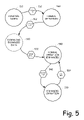
- FIG. 5 is a state diagram illustrating the operation of an embodiment of the utilization of the mapping information within a navigational system aspect of the present invention.
- a normal navigational system typical to those commercially available initially resides in a Powered Down state 510 until it is powered on 512 . Once power is applied to the navigational system, it commences operation in the Normal Operation mode 520 . In this mode, the navigational device typically receives GPS coordinate information through a GPS receiver, pulls up mapping information pertinent to the received GPS coordinates and displays that information, along with a location indicator on the display of the navigational system.
- the navigational system When the navigational system approaches a region in which the present invention has generated new mapping information 522 , such as an active mapping zone (AMZ), the navigational system enters into a transitional mode in which enhanced data is loaded into the navigational device 530 .
- This operation can be triggered based on a variety of circumstance or parameters and the present invention is not limited to any particular embodiment, nor the embodiments described herein for exemplary purposes.
- a navigational system comes within a threshold distance from an active mapping zone, it can be assumed that the probability of entering into the active mapping zone is increased and as such, available enhanced mapping information can be loaded into the navigational system. This enables the navigational system to be ready to display mapping information if the navigational system actually enters into the active mapping zone.
- the navigational system resumes normal operation however, it is equipped with enhanced mapping information 540 .
- the navigational system begins enhanced operation 550 .
- Enhanced operation means that the navigational system displays the newly generated mapping information for the uncharted or active mapping region to assist the user of the equipment. This information can be displayed instead of the normal mapping information for that region or, it can be overlaid on top of the standard mapping information. In either case, in the enhanced operation mode, the navigational system displays updated mapping information that otherwise would not be available to the navigational system.
- a navigational system that is not equipped with this aspect of the present invention would simply display the mapping information 320 as illustrated in FIG. 3A when the navigational system enters into the active mapping region; however, a navigational system equipped with this aspect of the present invention would display the enhanced mapping information as illustrated in FIG. 3G .
- the navigational system exits the active mapping zone 552 , it resumes normal operation but equipped with the enhanced data 540 .
- each of the verbs, “comprise” “include” and “have”, and conjugates thereof, are used to indicate that the object or objects of the verb are not necessarily a complete listing of members, components, elements or parts of the subject or subjects of the verb.
Abstract
Description
Claims (6)
Priority Applications (1)
| Application Number | Priority Date | Filing Date | Title |
|---|---|---|---|
| US11/164,683 US7606579B2 (en) | 2005-12-01 | 2005-12-01 | Auto mapping through location based triggers |
Applications Claiming Priority (1)
| Application Number | Priority Date | Filing Date | Title |
|---|---|---|---|
| US11/164,683 US7606579B2 (en) | 2005-12-01 | 2005-12-01 | Auto mapping through location based triggers |
Publications (2)
| Publication Number | Publication Date |
|---|---|
| US20070129082A1 US20070129082A1 (en) | 2007-06-07 |
| US7606579B2 true US7606579B2 (en) | 2009-10-20 |
Family
ID=38119462
Family Applications (1)
| Application Number | Title | Priority Date | Filing Date |
|---|---|---|---|
| US11/164,683 Expired - Fee Related US7606579B2 (en) | 2005-12-01 | 2005-12-01 | Auto mapping through location based triggers |
Country Status (1)
| Country | Link |
|---|---|
| US (1) | US7606579B2 (en) |
Cited By (21)
| Publication number | Priority date | Publication date | Assignee | Title |
|---|---|---|---|---|
| US20070168524A1 (en) * | 2005-12-30 | 2007-07-19 | Telenav, Inc. | Intelligent location based services and navigation hybrid system |
| US20090210277A1 (en) * | 2008-02-14 | 2009-08-20 | Hardin H Wesley | System and method for managing a geographically-expansive construction project |
| US20100094500A1 (en) * | 2008-10-14 | 2010-04-15 | Jin Seung-Hee | Telematics terminal and method for controlling vehicle using the same |
| US20100274604A1 (en) * | 2009-04-24 | 2010-10-28 | Benjamin Carter Crilly | Position Based Operational Tracking Of A Transport Refrigeration Unit |
| US20110153279A1 (en) * | 2009-12-23 | 2011-06-23 | Honeywell International Inc. | Approach for planning, designing and observing building systems |
| US20120101726A1 (en) * | 2010-10-21 | 2012-04-26 | Google Inc. | Frequency of Geographic Location Updates for an Electronic Device Based on User Communication |
| US20130198197A1 (en) * | 2012-02-01 | 2013-08-01 | Sri International | Method and apparatus for correlating and viewing disparate data |
| US8538687B2 (en) | 2010-05-04 | 2013-09-17 | Honeywell International Inc. | System for guidance and navigation in a building |
| US8773946B2 (en) | 2010-12-30 | 2014-07-08 | Honeywell International Inc. | Portable housings for generation of building maps |
| US8907785B2 (en) | 2011-08-10 | 2014-12-09 | Honeywell International Inc. | Locator system using disparate locator signals |
| US8990049B2 (en) | 2010-05-03 | 2015-03-24 | Honeywell International Inc. | Building structure discovery and display from various data artifacts at scene |
| US9141107B2 (en) | 2013-04-10 | 2015-09-22 | Google Inc. | Mapping active and inactive construction zones for autonomous driving |
| US9342928B2 (en) | 2011-06-29 | 2016-05-17 | Honeywell International Inc. | Systems and methods for presenting building information |
| US9563893B2 (en) | 2012-10-16 | 2017-02-07 | Fleetcor Technologies Operating Company, Llc | Method and system for detection of a fuel card usage exception |
| US20170293634A1 (en) * | 2016-04-07 | 2017-10-12 | Vizsafe, Inc. | Distributing maps, floor plans and blueprints to users based on their location |
| US9940615B2 (en) | 2012-10-16 | 2018-04-10 | Fleetcor Technologies Operating Company, Llc | Automated pairing of payment products and mobile to mobile devices |
| US20180157264A1 (en) * | 2016-12-02 | 2018-06-07 | International Business Machines Corporation | Control of driverless vehicles in construction zones |
| US10068024B2 (en) | 2012-02-01 | 2018-09-04 | Sri International | Method and apparatus for correlating and viewing disparate data |
| US10559208B1 (en) | 2019-01-25 | 2020-02-11 | Caterpillar Paving Products Inc | System and method for controlling reporting frequency |
| US10699571B2 (en) | 2017-12-04 | 2020-06-30 | Ford Global Technologies, Llc | High definition 3D mapping |
| US11408750B2 (en) | 2020-06-29 | 2022-08-09 | Toyota Research Institute, Inc. | Prioritizing collecting of information for a map |
Families Citing this family (43)
| Publication number | Priority date | Publication date | Assignee | Title |
|---|---|---|---|---|
| JP4745045B2 (en) * | 2005-12-15 | 2011-08-10 | アルパイン株式会社 | Navigation device |
| US7634294B2 (en) * | 2006-04-25 | 2009-12-15 | At&T Intellectual Property I, L.P. | Method and apparatus for exchanging content over distinct wireless access technologies |
| US8793066B2 (en) * | 2006-06-27 | 2014-07-29 | Microsoft Corporation | Route monetization |
| US7610151B2 (en) | 2006-06-27 | 2009-10-27 | Microsoft Corporation | Collaborative route planning for generating personalized and context-sensitive routing recommendations |
| AU2008228065A1 (en) * | 2007-03-19 | 2008-09-25 | Sumatra Bioscience Pte. Ltd. | Methods of producing haploid and doubled haploid oil palms |
| US8467808B1 (en) * | 2007-04-17 | 2013-06-18 | At&T Mobility Ii Llc | Mobile object location-based privacy protection |
| US8380744B2 (en) | 2007-07-17 | 2013-02-19 | At&T Intellectual Property I, L.P. | Methods, systems, and computer-readable media for generating a report indicating job availability |
| US8239232B2 (en) | 2007-07-17 | 2012-08-07 | At&T Intellectual Property I, L.P. | Methods, systems, and computer-readable media for providing commitments information relative to a turf |
| US20090024437A1 (en) * | 2007-07-17 | 2009-01-22 | Robert Ingman | Methods, Systems, and Computer-Readable Media for Providing A Ratio of Tasks Per Technician |
| US8352302B2 (en) * | 2007-07-17 | 2013-01-08 | At&T Intellectual Property I, L.P. | Methods, systems, and computer-readable media for determining a plurality of turfs from where to reallocate a workforce to a given turf |
| US8249905B2 (en) | 2007-07-17 | 2012-08-21 | At&T Intellectual Property I, Lp | Methods, systems, and computer-readable media for providing future job information |
| US8341547B2 (en) | 2007-07-17 | 2012-12-25 | At&T Intellectual Property I, L.P. | Methods, systems, and computer-readable media for providing contact information at turf level |
| US8489111B2 (en) | 2007-08-14 | 2013-07-16 | Mpanion, Inc. | Real-time location and presence using a push-location client and server |
| US8583079B2 (en) | 2007-08-14 | 2013-11-12 | Mpanion, Inc. | Rich presence status based on location, activity, availability and transit status of a user |
| US8050690B2 (en) | 2007-08-14 | 2011-11-01 | Mpanion, Inc. | Location based presence and privacy management |
| US8473198B2 (en) | 2007-12-14 | 2013-06-25 | Microsoft Corporation | Additional content based on intended travel destination |
| US8060297B2 (en) | 2007-12-14 | 2011-11-15 | Microsoft Corporation | Route transfer between devices |
| US8090532B2 (en) | 2007-12-14 | 2012-01-03 | Microsoft Corporation | Pedestrian route production |
| US8428859B2 (en) | 2007-12-14 | 2013-04-23 | Microsoft Corporation | Federated route production |
| US20090157312A1 (en) * | 2007-12-14 | 2009-06-18 | Microsoft Corporation | Social network based routes |
| US9141974B2 (en) * | 2008-01-16 | 2015-09-22 | Martin Kelly Jones | Systems and methods for determining mobile thing (MT) identification and/or MT motion activity using sensor data of wireless communication device |
| US8793065B2 (en) * | 2008-02-19 | 2014-07-29 | Microsoft Corporation | Route-based activity planner |
| US20090210276A1 (en) * | 2008-02-19 | 2009-08-20 | Microsoft Corporation | Ad hoc and opportunistic transportation services |
| US20100042940A1 (en) * | 2008-08-14 | 2010-02-18 | Caterpillar Inc. | Geofence system with integrated user interface |
| EP2404439B1 (en) * | 2009-03-04 | 2019-04-24 | Nokia Corporation | Position monitoring for a coverage area |
| EP2404386B1 (en) * | 2009-03-04 | 2017-10-25 | Nokia Technologies Oy | Screening terminal positions at a terminal |
| US8489331B2 (en) | 2010-04-29 | 2013-07-16 | Microsoft Corporation | Destination maps user interface |
| GB201010744D0 (en) * | 2010-06-25 | 2010-08-11 | Turner Andrew | A method for enabling a person to find a location within an area of space |
| US8467810B2 (en) * | 2010-11-29 | 2013-06-18 | Navteq B.V. | Method and system for reporting errors in a geographic database |
| EP2469233B1 (en) * | 2010-12-27 | 2016-05-18 | Deutsche Post AG | Route detecting system |
| US8639266B2 (en) | 2012-04-18 | 2014-01-28 | Google Inc. | Using peer devices to locate a mobile device |
| JP5888135B2 (en) * | 2012-06-12 | 2016-03-16 | ソニー株式会社 | Wireless communication apparatus, communication system, and information processing method |
| WO2014143252A1 (en) * | 2013-03-15 | 2014-09-18 | Eden Rock Communications, Llc | Method for tracking and utilizing operational run time of a network element |
| US9432807B2 (en) | 2013-05-23 | 2016-08-30 | Honeywell International Inc. | System and method with automatic radius crossing notification for global positioning system (GPS) tracker |
| US20150094083A1 (en) * | 2013-10-02 | 2015-04-02 | Blackberry Limited | Explicit and implicit triggers for creating new place data |
| KR20150069388A (en) * | 2013-12-13 | 2015-06-23 | 삼성전자주식회사 | Server and Method for transmitting data, and Mobile device and Method for sensing thereof |
| US9402189B2 (en) * | 2014-07-02 | 2016-07-26 | Here Global B.V. | Method and apparatus for providing activity-based map job |
| US10433106B2 (en) | 2016-11-30 | 2019-10-01 | Blazer and Flip Flops, Inc. | Personalized itinerary generation and mapping system |
| US11030266B2 (en) | 2016-11-30 | 2021-06-08 | Blazer and Flip Flops, Inc | Venue recommendations based on shared guest traits |
| US10438141B2 (en) | 2016-11-30 | 2019-10-08 | Blazer and Flip Flops, Inc | Venue traffic flow management |
| US11337030B2 (en) | 2016-11-30 | 2022-05-17 | Blazer and Flip Flops, Inc. | Assisted venue staff guidance |
| WO2018165147A1 (en) * | 2017-03-06 | 2018-09-13 | Blazer and Flip Flops, Inc. dba The Experience Engine | Dynamic journey mapping and recordkeeping |
| DE112018006781B4 (en) * | 2018-02-09 | 2021-12-30 | Mitsubishi Electric Corporation | Communication device and communication program |
Citations (15)
| Publication number | Priority date | Publication date | Assignee | Title |
|---|---|---|---|---|
| US4891761A (en) * | 1988-03-31 | 1990-01-02 | Mets, Inc. | Method for accurately updating positional information provided on a digital map |
| US5214757A (en) * | 1990-08-07 | 1993-05-25 | Georesearch, Inc. | Interactive automated mapping system |
| US5760742A (en) * | 1995-05-12 | 1998-06-02 | Trimble Navigation Limited | Integrated mobile GIS/GPS/AVL with wireless messaging capability |
| US6154152A (en) * | 1997-10-16 | 2000-11-28 | Toyota Jidosha Kabushiki Kaisha | Road data maintenance system and on-vehicle terminal apparatus compatible therewith |
| US6169515B1 (en) * | 1994-09-01 | 2001-01-02 | British Telecommunications Public Limited Company | Navigation information system |
| US20010027375A1 (en) * | 2000-03-29 | 2001-10-04 | Hitachi, Ltd. | Geographic information output system |
| US6377210B1 (en) * | 2000-02-25 | 2002-04-23 | Grey Island Systems, Inc. | Automatic mobile object locator apparatus and method |
| US6401068B1 (en) * | 1999-06-17 | 2002-06-04 | Navigation Technologies Corp. | Method and system using voice commands for collecting data for a geographic database |
| US6526352B1 (en) * | 2001-07-19 | 2003-02-25 | Intelligent Technologies International, Inc. | Method and arrangement for mapping a road |
| US6636802B1 (en) * | 1998-11-24 | 2003-10-21 | Matsushita Electric Industrial Co., Ltd. | Data structure of digital map file |
| US6704649B2 (en) * | 2001-07-31 | 2004-03-09 | Pioneer Corporation | Satellite navigation system of which map data are partially updateable |
| US6829484B1 (en) * | 1996-04-24 | 2004-12-07 | Fujitsu Limited | Mobile communicating system, and a mobile terminal, an information center and a storage medium used therein |
| US6970782B2 (en) * | 2000-12-28 | 2005-11-29 | Pioneer Corporation | System for updating navigation information and apparatus for distributing updated navigation information |
| US20060028377A1 (en) * | 2004-08-05 | 2006-02-09 | Charles Abraham | Method and apparatus for adjusting a measurement cycle in a satellite positioning system signal receiver |
| US7031836B2 (en) * | 2003-10-28 | 2006-04-18 | Thales Navigation, Inc. | Grid mapping utility for a GPS device |
-
2005
- 2005-12-01 US US11/164,683 patent/US7606579B2/en not_active Expired - Fee Related
Patent Citations (15)
| Publication number | Priority date | Publication date | Assignee | Title |
|---|---|---|---|---|
| US4891761A (en) * | 1988-03-31 | 1990-01-02 | Mets, Inc. | Method for accurately updating positional information provided on a digital map |
| US5214757A (en) * | 1990-08-07 | 1993-05-25 | Georesearch, Inc. | Interactive automated mapping system |
| US6169515B1 (en) * | 1994-09-01 | 2001-01-02 | British Telecommunications Public Limited Company | Navigation information system |
| US5760742A (en) * | 1995-05-12 | 1998-06-02 | Trimble Navigation Limited | Integrated mobile GIS/GPS/AVL with wireless messaging capability |
| US6829484B1 (en) * | 1996-04-24 | 2004-12-07 | Fujitsu Limited | Mobile communicating system, and a mobile terminal, an information center and a storage medium used therein |
| US6154152A (en) * | 1997-10-16 | 2000-11-28 | Toyota Jidosha Kabushiki Kaisha | Road data maintenance system and on-vehicle terminal apparatus compatible therewith |
| US6636802B1 (en) * | 1998-11-24 | 2003-10-21 | Matsushita Electric Industrial Co., Ltd. | Data structure of digital map file |
| US6401068B1 (en) * | 1999-06-17 | 2002-06-04 | Navigation Technologies Corp. | Method and system using voice commands for collecting data for a geographic database |
| US6377210B1 (en) * | 2000-02-25 | 2002-04-23 | Grey Island Systems, Inc. | Automatic mobile object locator apparatus and method |
| US20010027375A1 (en) * | 2000-03-29 | 2001-10-04 | Hitachi, Ltd. | Geographic information output system |
| US6970782B2 (en) * | 2000-12-28 | 2005-11-29 | Pioneer Corporation | System for updating navigation information and apparatus for distributing updated navigation information |
| US6526352B1 (en) * | 2001-07-19 | 2003-02-25 | Intelligent Technologies International, Inc. | Method and arrangement for mapping a road |
| US6704649B2 (en) * | 2001-07-31 | 2004-03-09 | Pioneer Corporation | Satellite navigation system of which map data are partially updateable |
| US7031836B2 (en) * | 2003-10-28 | 2006-04-18 | Thales Navigation, Inc. | Grid mapping utility for a GPS device |
| US20060028377A1 (en) * | 2004-08-05 | 2006-02-09 | Charles Abraham | Method and apparatus for adjusting a measurement cycle in a satellite positioning system signal receiver |
Non-Patent Citations (6)
| Title |
|---|
| Authors: Anindya S. Paul and Eric A. Wan□□Title: Dual Kalman Filters for Autonomous Terrain Aided Navigation in Unknown Environments□□Published: Aug. 2005, pp. 2784-2789, vol. 5□□Source: IEEE. * |
| Authors: Arunas Stockus, Alain Bouju, Frederic Bertrand and Patrice Boursier□□Title: Integrating GPS Data within Embedded Internet GIS□□Published: Nov. 1999□□Source: ACM. * |
| Authors: Chieko Arai, Naoko Matsuda and Masaaki Shikada□□Title: Management of Mapping in Local Government Using Remote Sensing and the Real Time GIS□□Published: Jun. 2002, pp. 3145-3147, vol. 6□□Source: IEEE. * |
| Authors: Harsha Tummala and Joel Jones□□Title: Mobility Support and Location Awareness: Developing Spatially-Aware Content Management Systems for Dynamic, Location-Specific Information in Mobile Environments□□Published: Sep. 2005□□Source: ACM. * |
| Authors: Jim Engelhardt□□Title: Mobile GIS Takes IT to the Field□□Published: Sep. 2002, vol. 12, Iss. 9, pp. 16 & 18□□Source: ProQuest. * |
| Title: Red Hen Unveils Mobile for Mediamapper Elite□□Published: Jul. 2003, vol. 13, Iss. 7□□Source: ProQuest. * |
Cited By (36)
| Publication number | Priority date | Publication date | Assignee | Title |
|---|---|---|---|---|
| US10416980B2 (en) * | 2005-12-30 | 2019-09-17 | Telenav, Inc. | Intelligent location based services and navigation hybrid system |
| US20070168524A1 (en) * | 2005-12-30 | 2007-07-19 | Telenav, Inc. | Intelligent location based services and navigation hybrid system |
| US20090210277A1 (en) * | 2008-02-14 | 2009-08-20 | Hardin H Wesley | System and method for managing a geographically-expansive construction project |
| US20100094500A1 (en) * | 2008-10-14 | 2010-04-15 | Jin Seung-Hee | Telematics terminal and method for controlling vehicle using the same |
| US8825369B2 (en) * | 2008-10-14 | 2014-09-02 | Lg Electronics Inc. | Telematics terminal and method for controlling vehicle using the same |
| US20100274604A1 (en) * | 2009-04-24 | 2010-10-28 | Benjamin Carter Crilly | Position Based Operational Tracking Of A Transport Refrigeration Unit |
| US20110153279A1 (en) * | 2009-12-23 | 2011-06-23 | Honeywell International Inc. | Approach for planning, designing and observing building systems |
| US8532962B2 (en) | 2009-12-23 | 2013-09-10 | Honeywell International Inc. | Approach for planning, designing and observing building systems |
| US8990049B2 (en) | 2010-05-03 | 2015-03-24 | Honeywell International Inc. | Building structure discovery and display from various data artifacts at scene |
| US8538687B2 (en) | 2010-05-04 | 2013-09-17 | Honeywell International Inc. | System for guidance and navigation in a building |
| US20120101726A1 (en) * | 2010-10-21 | 2012-04-26 | Google Inc. | Frequency of Geographic Location Updates for an Electronic Device Based on User Communication |
| US8249621B2 (en) * | 2010-10-21 | 2012-08-21 | Google Inc. | Frequency of geographic location updates for an electronic device based on user communication |
| US8773946B2 (en) | 2010-12-30 | 2014-07-08 | Honeywell International Inc. | Portable housings for generation of building maps |
| US10854013B2 (en) | 2011-06-29 | 2020-12-01 | Honeywell International Inc. | Systems and methods for presenting building information |
| US9342928B2 (en) | 2011-06-29 | 2016-05-17 | Honeywell International Inc. | Systems and methods for presenting building information |
| US10445933B2 (en) | 2011-06-29 | 2019-10-15 | Honeywell International Inc. | Systems and methods for presenting building information |
| US8907785B2 (en) | 2011-08-10 | 2014-12-09 | Honeywell International Inc. | Locator system using disparate locator signals |
| US9053194B2 (en) * | 2012-02-01 | 2015-06-09 | Sri International | Method and apparatus for correlating and viewing disparate data |
| US10068024B2 (en) | 2012-02-01 | 2018-09-04 | Sri International | Method and apparatus for correlating and viewing disparate data |
| US20130198197A1 (en) * | 2012-02-01 | 2013-08-01 | Sri International | Method and apparatus for correlating and viewing disparate data |
| US9576291B2 (en) | 2012-10-16 | 2017-02-21 | Fleetcor Technologies Operating Company, Llc | Method and system for detection of a fuel card usage exception |
| US9563893B2 (en) | 2012-10-16 | 2017-02-07 | Fleetcor Technologies Operating Company, Llc | Method and system for detection of a fuel card usage exception |
| US9940615B2 (en) | 2012-10-16 | 2018-04-10 | Fleetcor Technologies Operating Company, Llc | Automated pairing of payment products and mobile to mobile devices |
| US9141107B2 (en) | 2013-04-10 | 2015-09-22 | Google Inc. | Mapping active and inactive construction zones for autonomous driving |
| US10317906B2 (en) | 2013-04-10 | 2019-06-11 | Waymo Llc | Mapping active and inactive construction zones for autonomous driving |
| US9575490B2 (en) | 2013-04-10 | 2017-02-21 | Google Inc. | Mapping active and inactive construction zones for autonomous driving |
| US11287823B2 (en) | 2013-04-10 | 2022-03-29 | Waymo Llc | Mapping active and inactive construction zones for autonomous driving |
| US20170293634A1 (en) * | 2016-04-07 | 2017-10-12 | Vizsafe, Inc. | Distributing maps, floor plans and blueprints to users based on their location |
| US10663318B2 (en) * | 2016-04-07 | 2020-05-26 | Vizsafe, Inc. | Distributing maps, floor plans and blueprints to users based on their location |
| US20180157264A1 (en) * | 2016-12-02 | 2018-06-07 | International Business Machines Corporation | Control of driverless vehicles in construction zones |
| US11238726B2 (en) * | 2016-12-02 | 2022-02-01 | International Business Machines Corporation | Control of driverless vehicles in construction zones |
| US10699571B2 (en) | 2017-12-04 | 2020-06-30 | Ford Global Technologies, Llc | High definition 3D mapping |
| US10559208B1 (en) | 2019-01-25 | 2020-02-11 | Caterpillar Paving Products Inc | System and method for controlling reporting frequency |
| US11408750B2 (en) | 2020-06-29 | 2022-08-09 | Toyota Research Institute, Inc. | Prioritizing collecting of information for a map |
| US20220260384A1 (en) * | 2020-06-29 | 2022-08-18 | Toyota Research Institute, Inc. | Prioritizing collecting of information for a map |
| US11841239B2 (en) * | 2020-06-29 | 2023-12-12 | Toyota Jidosha Kabushiki Kaisha | Prioritizing collecting of information for a map |
Also Published As
| Publication number | Publication date |
|---|---|
| US20070129082A1 (en) | 2007-06-07 |
Similar Documents
| Publication | Publication Date | Title |
|---|---|---|
| US7606579B2 (en) | Auto mapping through location based triggers | |
| US6871139B2 (en) | Dual map system for navigation and wireless communication | |
| US8614629B2 (en) | Dynamic reporting scheme for location based services | |
| EP1987502B1 (en) | Apparatus and methods for speed management and control | |
| US6411899B2 (en) | Position based personal digital assistant | |
| US5938721A (en) | Position based personal digital assistant | |
| US8983764B2 (en) | Dynamic determination of device location reporting frequency | |
| KR100729707B1 (en) | Method and system to allocate freight using Global Positioning System and Global Positioning System | |
| US20060292984A1 (en) | Rfid vehicle-tracking system using mobile transceivers and stationary transponders | |
| US20090216443A1 (en) | Systems and methods for notification of location via an electronic device | |
| US20070143017A1 (en) | GPS equipped devices that utilize geographical navigation bundles | |
| KR19980068114A (en) | Comprehensive Traffic Information Management System Using Mobile Phone | |
| CN101097143A (en) | Process for establishing self-setting navigation way | |
| US20040252050A1 (en) | Vehicle fleet navigation system | |
| Baby Shalini | Global Positioning System (GPS) and internet of things (IOT) based vehicle tracking system | |
| KR20010015007A (en) | Mobile position tracer and method | |
| US10591308B2 (en) | Dynamic GPS location update | |
| US10288744B2 (en) | Dynamic GPS location update | |
| RU2615025C1 (en) | Building complex computer control system | |
| Vanmore et al. | Smart vehicle tracking using GPS | |
| CN101806597B (en) | Intelligent information system-based remote interactive navigation method and system | |
| Sahane et al. | IoT based Vehicle Tracking using GPS | |
| JP2000266552A (en) | Navigation system utilizing gps | |
| Donecker et al. | TECHNICAL REPORT DOCUMENTATION PAGE | |
| Berney | Supply Chain Basics: Tracking Trucks With GPS |
Legal Events
| Date | Code | Title | Description |
|---|---|---|---|
| AS | Assignment |
Owner name: DISCRETE WIRELESS, GEORGIA Free format text: ASSIGNMENT OF ASSIGNORS INTEREST;ASSIGNOR:THACHER, JEFFERY W.;REEL/FRAME:016839/0291 Effective date: 20051130 |
|
| AS | Assignment |
Owner name: SILICON VALLEY BANK, CALIFORNIA Free format text: SECURITY AGREEMENT;ASSIGNOR:DISCRETE WIRELESS, INC.;REEL/FRAME:018123/0917 Effective date: 20060815 |
|
| AS | Assignment |
Owner name: DISCRETE WIRELESS, INC., GEORGIA Free format text: RELEASE OF SECURITY INTEREST RECORDED AT REEL/FRAME 018123/0917;ASSIGNOR:SILICON VALLEY BANK;REEL/FRAME:023729/0004 Effective date: 20091231 |
|
| AS | Assignment |
Owner name: SILICON VALLEY BANK, AS ADMINISTRATIVE AGENT, GEOR Free format text: SECURITY AGREEMENT;ASSIGNOR:DISCRETE WIRELESS, INC.;REEL/FRAME:023755/0420 Effective date: 20091231 |
|
| REMI | Maintenance fee reminder mailed | ||
| LAPS | Lapse for failure to pay maintenance fees | ||
| STCH | Information on status: patent discontinuation |
Free format text: PATENT EXPIRED DUE TO NONPAYMENT OF MAINTENANCE FEES UNDER 37 CFR 1.362 |
|
| FP | Lapsed due to failure to pay maintenance fee |
Effective date: 20131020 |