US4652884A - Satellite navigational system and method - Google Patents
Satellite navigational system and method Download PDFInfo
- Publication number
- US4652884A US4652884A US06/755,109 US75510985A US4652884A US 4652884 A US4652884 A US 4652884A US 75510985 A US75510985 A US 75510985A US 4652884 A US4652884 A US 4652884A
- Authority
- US
- United States
- Prior art keywords
- satellites
- navigational
- synchronous
- data
- time
- Prior art date
- Legal status (The legal status is an assumption and is not a legal conclusion. Google has not performed a legal analysis and makes no representation as to the accuracy of the status listed.)
- Expired - Fee Related
Links
Images


Classifications
-
- G—PHYSICS
- G01—MEASURING; TESTING
- G01S—RADIO DIRECTION-FINDING; RADIO NAVIGATION; DETERMINING DISTANCE OR VELOCITY BY USE OF RADIO WAVES; LOCATING OR PRESENCE-DETECTING BY USE OF THE REFLECTION OR RERADIATION OF RADIO WAVES; ANALOGOUS ARRANGEMENTS USING OTHER WAVES
- G01S5/00—Position-fixing by co-ordinating two or more direction or position line determinations; Position-fixing by co-ordinating two or more distance determinations
- G01S5/02—Position-fixing by co-ordinating two or more direction or position line determinations; Position-fixing by co-ordinating two or more distance determinations using radio waves
- G01S5/14—Determining absolute distances from a plurality of spaced points of known location
-
- G—PHYSICS
- G01—MEASURING; TESTING
- G01S—RADIO DIRECTION-FINDING; RADIO NAVIGATION; DETERMINING DISTANCE OR VELOCITY BY USE OF RADIO WAVES; LOCATING OR PRESENCE-DETECTING BY USE OF THE REFLECTION OR RERADIATION OF RADIO WAVES; ANALOGOUS ARRANGEMENTS USING OTHER WAVES
- G01S19/00—Satellite radio beacon positioning systems; Determining position, velocity or attitude using signals transmitted by such systems
- G01S19/38—Determining a navigation solution using signals transmitted by a satellite radio beacon positioning system
- G01S19/39—Determining a navigation solution using signals transmitted by a satellite radio beacon positioning system the satellite radio beacon positioning system transmitting time-stamped messages, e.g. GPS [Global Positioning System], GLONASS [Global Orbiting Navigation Satellite System] or GALILEO
- G01S19/42—Determining position
- G01S19/421—Determining position by combining or switching between position solutions or signals derived from different satellite radio beacon positioning systems; by combining or switching between position solutions or signals derived from different modes of operation in a single system
- G01S19/425—Determining position by combining or switching between position solutions or signals derived from different satellite radio beacon positioning systems; by combining or switching between position solutions or signals derived from different modes of operation in a single system by combining or switching between signals derived from different satellite radio beacon positioning systems
-
- B—PERFORMING OPERATIONS; TRANSPORTING
- B64—AIRCRAFT; AVIATION; COSMONAUTICS
- B64G—COSMONAUTICS; VEHICLES OR EQUIPMENT THEREFOR
- B64G1/00—Cosmonautic vehicles
- B64G1/10—Artificial satellites; Systems of such satellites; Interplanetary vehicles
- B64G1/1014—Navigation satellites
-
- B—PERFORMING OPERATIONS; TRANSPORTING
- B64—AIRCRAFT; AVIATION; COSMONAUTICS
- B64G—COSMONAUTICS; VEHICLES OR EQUIPMENT THEREFOR
- B64G1/00—Cosmonautic vehicles
- B64G1/10—Artificial satellites; Systems of such satellites; Interplanetary vehicles
- B64G1/1085—Swarms and constellations
Definitions
- the invention relates to a satellite navigational system and method. More particularly, it relates to a navigational system and method using satellites for transmitting coded time signals as well as additional navigational data used for determining position, locating operations, navigation, etc.
- the reference points conventionally used are radio beacons in a precisely known, fixed position.
- the use of satellites brings about substantial advantages. Due to the higher frequencies involved, measuring accuracy is enhanced. Longer reaching and more economical systems may be developed as satellite coverage becomes available over large areas on the earth's surface.
- the three-dimensional reference points provided by satellites permit three-dimensional and, thus, more precise fixing of vehicle positions, satisfying most of the user's requirements.
- any receiver of ranging signals from a satellite must be continuously supplied with other information as well, i.e., data on the position of the respective satellite and on the exact reading of the satellite clock at the time of transmission of the signals, so as to be able to determine its proper position from the signals received.
- Satellite navigation in the specific sense means determining the proper position and, if necessary, the proper movements of a vehicle with the aid of satellites.
- proper position is determined by the propagation time and/or change in propagation time of electromagnetic waves between the vehicle and a number of reference points.
- Two or three-dimensional position fixing requires measuring operations involving from two to four reference points depending on whether the single-way or two-way method is used. For high measuring accuracy, these reference points must also be in a favorable geometrical position relative to the cruising vehicle. As such, favorable geometrical groupings covering the entire surface of the earth cannot satisfactorily be realized using satellites in geosynchronous orbit.
- a navigational satellite system extending around the earth always includes orbiting satellites in a non-geosynchronous position, with their orbital paths at a lower plane than those of geosynchronous satellites.
- each space segment includes five satellites positioned in polar orbits transmitting time signals on two different frequencies, together with data on their respective orbits.
- Slow moving vehicles may determine their positions at larger time intervals by measuring and utilizing, respectively, the Doppler effect during each transit recurring at intervals of from two to ten hours.
- a plurality of satellites must continuously circle the earth at varying planes of orbit (three-dimensional single-way position fixing requires e.g., four simultaneously visible satellites).
- NAVSTAR-GPS Global Positioning System
- the synchronized time signals required for single-way ranging operations shall instead be produced on the ground, together with the above-mentioned additional data. They will be transmitted from a plurality of ground stations distributed over the earth to the navigational satellites and retransmitted from there to the cruising vehicles. Installation and operation of these extensive and complex ground stations will, however, consume a large part of what has been saved in the equipment of the satellites. Not even the proposed modification of the European GRANAS system will noticeably reduce the total costs of the system. The intended simplification of the ground stations through proper position fixing within the satellites will again bring about somewhat higher expenditure for the satellites.
- GLONAS presently being installed in the Soviet Union, it is known only that it has a strong resemblance to the U.S. system NAVSTAR-GPS.
- All presently existing or planned navigational systems using satellites utilize a plurality of similarly designed, orbiting satellites which emit locating signals, in the form of time marks, as well as additional, satellite specific information, i.e., data required for reading and utilizing these time signals in position fixing and navigational operations. This data is corrected at certain intervals by the ground control equipment and subsequently retransmitted to the satellites for storage. Also included is data for contacting other navigational satellites and conducting propagation corrections, or retransmission of the locating signal on a second carrier frequency. Moreover, all previously disclosed or proposed systems are limited to the determination of proper position and speed of vehicles.
- a plurality of orbiting satellites the so-called navigational satellites, or ground stations, emit only a time signal comprising an identification code.
- Any information data required for determining positions, locating operations and navigation as well as any data on orbiting navigational satellites and ground stations are distributed by means of a small number of satellites positioned in geosynchronous or quasi-geosynchronous orbit, the so-called synchronous satellites. Data from the synchronous satellites may be transmitted together with a time signal at precisely the same frequency, at which the navigational satellites emit their time signals.
- a reference in time is established between the various satellite signals by having each of the synchronous satellites emit its time code signal on two different frequencies, the first frequency serving to transmit the time signal to the user and the second frequency serving to transfer the time signal to the simple navigational satellites.
- the simple navigational satellites transmit the time signal only on a single carrier frequency, and corrections required because of ionospheric influences or disturbances are made by utilizing the signals transmitted by the synchronous satellites on the two different frequencies.
- Some of the navigational satellites may retransmit data and additional information received from one of the synchronous satellites so as to supply particular regions, e.g., the polar regions.
- cooperation with orbiting beacon satellites of other navigational systems is established by proper synchronization of the first frequency and the various time code signals.
- all functions of the plurality of navigational satellites may also be served by ground stations controlled in a similar manner by one of the synchronous satellites.
- individual vehicles may be sequentially interrogated with the aid of information data transmitted together with the navigational signal from one of the ground control stations via one of the synchronous satellites so as to induce the vehicles to send out their positions and identification codes on a further carrier frequency.
- the time signal transmitted by one of the synchronous satellites be used by cruising vehicles for automatically maintaining communication, by determining the direction of the incoming signal by position fixing methods and focusing the antenna of the communication equipment in the vehicle in alignment to trace the respective synchronous satellite on the basis of the measured directional data.
- a global navigational system includes at least three satellites in geosynchronous or quasi-geosynchronous orbit as well as associated ground control stations capable of being regionally operated.
- a plurality of orbiting satellites are jointly used by the various subsystems consisting of a synchronous satellite and the ground control equipment associated therewith.
- the functions of the unavoidably large number of orbiting navigational satellites may be reduced to a far greater extent than with the planned U.S. or European systems such as NAVSTAR or GRANAS. Only that function which is absolutely necessary, i.e., the transmission of a time signal is left with the satellites.
- a global navigational system As only part of the earth's surface may be reached by a single satellite in geosynchronous or quasi-geosynchronous orbit, a global navigational system according to the invention must comprise at least three synchronous satellites to supply information to all parts of the earth.
- FIG. 1 is a schematical diagram of the most important functions of the system according to the invention when determining the position of a user;
- FIG. 2 is a schematical diagram of the single-way measuring method for determining the orbital path of a satellite and comparing the clocks within the satellites with a clock on the ground, with only a single carrier frequency being used by the simplified navigational satellites;
- FIG. 3 is a schematical diagram of proper position fixing by a user with the aid of the system according to the invention, the simple navigational satellites being replaced by a ground transponder station;
- FIG. 4 is a schematical diagram of monitoring and transmission of distress signal with the aid of the system according to the invention.
- FIG. 5 is a schematical diagram of a system according to the invention which covers the entire surface of the earth and includes at least three synchronous satellites as well as the ground control station and receiving monitor stations associated therewith.
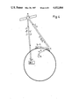
- FIG. 1 shown in FIG. 1 are the most important functions of the navigational satellite system of the invention during position fixing of user P.
- a satellite in geosynchronous or quasi-geosynchronous orbit i.e., so-called synchronous satellite M
- the orbiting simple satellites i.e., so-called navigational satellites N 1 to N 3 .
- User P here represented as a cruising ship, is located on the surface E of the earth which is indicated by the circular area.
- a ground control station K Also located on surface E are a ground control station K and the monitor stations m associated therewith.
- the various connections between synchronous satellite M, navigational satellites N 1 to N 3 , user P and ground control station K are shown as solid or dotted lines and include designators indicating frequency and data type.
- user P receives time signals from navigational satellites N 1 to N 3 and synchronous satellite M; the signals are distinguishable by codes in orthogonal relationship to each other, the respective codes being specified at the various "connecting lines".
- Signals arriving from synchronous satellite M also include any data I s required for position fixing and further navigation.
- Data I s originates at ground control station K from where it is continuously transmitted to synchronous satellite M on a further frequency f 3 .
- a time signal comprising code signal K M is simultaneously transmitted on frequency f 3 to synchronous satellite M, serving as a reference between the time of the clock in ground control station K and the time of synchronous satellite M.
- navigational satellites N 1 to N 3 produce the time signal to be transmitted by means of a stable oscillator accommodated in each of these satellites
- the stability of such satellite oscillators may be lower by about one order of magnitude in the system of the invention than, e.g., in the planned U.S. navigational system NAVSTAR-GPS. This is due to the fact that in the present invention the parameters of satellites and clocks may be corrected and brought up-to-date at far more frequent intervals, whereas in the NAVSTAR-GPS system, a 24-hour rhythm must generally be observed for such corrections.
- the so-called clock oscillators in the various navigational satellites N 1 to N 3 may be omitted.
- the time signals of the navigational satellites may be controlled through synchronous satellite M by transmitting time code signals K M on a transmitting frequency f 2 .
- any user P is aware at any given time of the exact position of each navigational satellite N i and may thus calculate the delay in time between transmission of code signal K N .sbsb.i by satellite N i and transmission of code signal K M by synchronous satellite M.
- user P obtains a series of measuring data that may be read and treated in the same manner as the measuring data obtained from four satellites comprising accurately synchronized clocks.
- synchronous satellite M need not be equipped with a high-stability oscillator if the time signals arriving at synchronous satellite M from ground control station K are directly used for controlling the time cycles of the navigational satellites N i .
- FIG. 2 Monitoring of the orbital paths of synchronous satellite M and navigational satellites N i as well as comparative checks between satellite clocks and the clock in a ground control station are conveniently conducted in accordance with the conventional single-way ranging method as illustrated in FIG. 2.
- Four synchronized receiving monitor stations m determine the arrival time of time signals from the various satellites, namely synchronous satellite M and navigational satellites N i , as compared to a ground reference time. The measuring results are then transmitted to ground control station K for computation of the orbital paths of the satellites and eventual deviations of the satellite times.
- each orbiting navigational satellite of the prior systems has to emit time signals at two different frequencies.
- the navigational satellites emit their time signals on a single frequency f 1 since ionospheric disturbances may be determined at any give time with the aid of the time signals emitted on two frequencies by synchronous satellite M. If required, users may directly obtain this information by receiving frequency f 2 .
- any function of the various navigational satellites N i may be taken over by some ground control station.
- ground stations equipped with regenerative transponders which merely transpose the time signal received from a synchronous satellite M with respect to frequency and code before it is retransmitted.
- position and identification code of each ground transponder T i are suitably modulated upon the time signal of the respective transponder in the usual manner.
- FIG. 3 illustrates how user P may determine his own position with the aid of synchronous satellite M.
- user P determines the proper position coordinates by receiving signals from three ground transponders T 1 to T 3 , namely f 1 +K T .sbsb.1, f 1 +K T .sbsb.2 and f 1 +K T .sbsb.3, as well as signal f 1 +K M from synchronous satellite M.
- f 1 +K T .sbsb.1 f 1 +K T .sbsb.2 and f 1 +K T .sbsb.3
- signal f 1 +K M from synchronous satellite M.
- transponders T 1 to T 3 must also transmit data I s as received from synchronous satellite M.
- ground transponder stations T i are of interest where accurate navigation relative to existing fixed reference points is required within a relatively small area, e.g., for airplanes in the vicinity of airports, for ships in ports or coastal waters, and for land vehicles.
- the special advantages of such ground transponder stations T i reside in the availability of higher transmitting power, the reduced distance between transmitter, i.e., ground transponder T i , and user P; the practical non-existence of ionospheric influences if transponder stations T i are not too far removed from each other; and in the fact that a permanent, optimized geometrical arrangement of fixed reference points may thus be provided in certain areas.
- Monitoring may be effected by a ground control station by transmitting interrogation signals at predetermined intervals to the vehicles to be monitored, causing those vehicles to transmit their positions together with their respective identification codes. Automatic transmission of position and identification code is particularly convenient. Vehicle interrogation requires relatively few address bits within data I s transmitted by ground control station K. Thus, the monitored vehicles are induced to sequentially transmit their respective positions at time intervals to be determined by ground control station K.
- Receivers of the position data transmitted by the individual vehicles may be other vehicles in the vicinity, neighboring monitor stations B, and especially ground control station K which receives position data and identification code through a detour via synchronous satellite M where the data are transposed and transmitted on a further carrier frequency, e.g., f 5 .
- the same channel of communication may be used for transmitting distress signals to ground control station K.
- FIG. 5 shows three synchronous satellites M 1 to M 3 , a plurality of orbiting navigational satellites N 1 to N 3 as well as three control stations K 1 to K 3 and a number of receiving monitor stations m 1 ,2 to m' 2 ,3 distributed over the earth's surface.
- Monitor stations m 1 ,2, m' 1 ,2 ; m 1 ,3, m' 1 ,3 ; m 2 ,3, m' 2 ,3 are suitably in locations where they may receive signals from two synchronous satellites each, namely M 1 , M 2 ; M 1 , M 3 and M 2 , M 3 , respectively, to retransmit the measuring data thus received to ground control stations K 1 to K 3 .
- Synchronous satellites which are stationary above some precise point of the equator may cover only the regions up to about 80° of northern and southern latitude. If the navigational system of the invention shall also supply information to the polar regions, one may either equip some of the navigational satellites N i orbiting on a polar route, i.e., on a path crossing the poles of the earth, with specific transponders for retransmitting informational data I s received from synchronous satellites, or the synchronous satellites M i must follow an orbital path that is inclined with respect to the equator.
- synchronous satellites M i will at times travel over the northern hemisphere and at other times over the southern hemisphere, moving in varying patterns relative to a fixed point on the earth's surface. These orbits are referred to as quasi-geosynchronous orbits. They have been comprehensively described in prior literature and may still be further optimized with a view to complete coverage of the polar regions.
Abstract
Description
Claims (18)
Applications Claiming Priority (2)
| Application Number | Priority Date | Filing Date | Title |
|---|---|---|---|
| DE3426851 | 1984-07-20 | ||
| DE3426851A DE3426851C1 (en) | 1984-07-20 | 1984-07-20 | Satellite navigation system |
Publications (1)
| Publication Number | Publication Date |
|---|---|
| US4652884A true US4652884A (en) | 1987-03-24 |
Family
ID=6241183
Family Applications (1)
| Application Number | Title | Priority Date | Filing Date |
|---|---|---|---|
| US06/755,109 Expired - Fee Related US4652884A (en) | 1984-07-20 | 1985-07-15 | Satellite navigational system and method |
Country Status (5)
| Country | Link |
|---|---|
| US (1) | US4652884A (en) |
| JP (1) | JPH083522B2 (en) |
| DE (1) | DE3426851C1 (en) |
| FR (1) | FR2568017B1 (en) |
| GB (1) | GB2162013B (en) |
Cited By (80)
| Publication number | Priority date | Publication date | Assignee | Title |
|---|---|---|---|---|
| WO1987006713A1 (en) * | 1986-05-01 | 1987-11-05 | Magnavox Government And Industrial Electronics Com | Method and apparatus for precision dynamic differential positioning |
| US4809005A (en) * | 1982-03-01 | 1989-02-28 | Western Atlas International, Inc. | Multi-antenna gas receiver for seismic survey vessels |
| WO1989007549A1 (en) * | 1986-02-24 | 1989-08-24 | Ausilio Robert F D | System for testing space weapons |
| US4918609A (en) * | 1988-10-11 | 1990-04-17 | Koji Yamawaki | Satellite-based position-determining system |
| US4943808A (en) * | 1988-03-02 | 1990-07-24 | Centre National D'etudes Spatiales | Communications system with moving bodies with the aid of satellites |
| US5014066A (en) * | 1982-03-01 | 1991-05-07 | Western Atlas International, Inc. | System for simultaneously deriving position information from a plurality of satellite transmissions |
| US5099245A (en) * | 1987-10-23 | 1992-03-24 | Hughes Aircraft Company | Vehicle location system accuracy enhancement for airborne vehicles |
| US5191341A (en) * | 1987-12-01 | 1993-03-02 | Federation Francaise De Voile | System for sea navigation or traffic control/assistance |
| US5218467A (en) * | 1990-12-28 | 1993-06-08 | Nasa And Laser Data Technology, Inc. | Multi-access laser communications transceiver system |
| US5278863A (en) * | 1992-04-10 | 1994-01-11 | Cd Radio Incorporated | Radio frequency broadcasting systems and methods using two low-cost geosynchronous satellites |
| US5313490A (en) * | 1992-12-31 | 1994-05-17 | Gte Government Systems Corporation | Acquisition apparatus for DSSS communications |
| US5313491A (en) * | 1992-12-31 | 1994-05-17 | Gte Government Systems Corporation | Acquisition method for DSSS communications |
| US5365447A (en) * | 1991-09-20 | 1994-11-15 | Dennis Arthur R | GPS and satelite navigation system |
| US5375059A (en) * | 1990-02-05 | 1994-12-20 | Caterpillar Inc. | Vehicle position determination system and method |
| US5382958A (en) * | 1992-12-17 | 1995-01-17 | Motorola, Inc. | Time transfer position location method and apparatus |
| US5420594A (en) * | 1993-10-21 | 1995-05-30 | Motorola, Inc. | Multi-mode position location method |
| US5450448A (en) * | 1993-04-30 | 1995-09-12 | Trimble Navigation Limited | Removal of signal errors for differential satellite positioning systems |
| US5452216A (en) * | 1993-08-02 | 1995-09-19 | Mounce; George R. | Microprocessor-based navigational aid system with external electronic correction |
| US5543813A (en) * | 1993-08-12 | 1996-08-06 | Kokusai Denshin Denwa Kabushiki Kaisha | System for determining and registering location of mobile terminal for communication system with non-geosynchronous satellites |
| US5555503A (en) * | 1989-12-11 | 1996-09-10 | Caterpillar Inc. | System and method for providing accurate vehicle positioning using spatial bias techniques |
| US5592471A (en) * | 1995-04-21 | 1997-01-07 | Cd Radio Inc. | Mobile radio receivers using time diversity to avoid service outages in multichannel broadcast transmission systems |
| US5760737A (en) * | 1996-09-11 | 1998-06-02 | Honeywell Inc. | Navigation system with solution separation apparatus for detecting accuracy failures |
| US5786773A (en) * | 1996-10-02 | 1998-07-28 | The Boeing Company | Local-area augmentation system for satellite navigation precision-approach system |
| US5805200A (en) * | 1982-03-01 | 1998-09-08 | Western Atlas International, Inc. | System for determining position from pseudorandomly modulated radio signals |
| US5852790A (en) * | 1996-04-22 | 1998-12-22 | Westinghouse Savannah River Company | Global positioning system recorder and method government rights |
| US5906337A (en) * | 1995-10-03 | 1999-05-25 | Trw Inc. | Multiple altitude satellite relay system and method |
| US5971324A (en) * | 1995-10-03 | 1999-10-26 | Trw Inc. | Multiple altitude satellite relay system and method |
| US6023616A (en) * | 1998-03-10 | 2000-02-08 | Cd Radio Inc. | Satellite broadcast receiver system |
| US6040798A (en) * | 1995-10-24 | 2000-03-21 | International Mobile Satellite Organization | Satellite radiodetermination |
| US6223019B1 (en) | 1996-03-14 | 2001-04-24 | Sirius Satellite Radio Inc. | Efficient high latitude service area satellite mobile broadcasting systems |
| US20020144294A1 (en) * | 2001-02-02 | 2002-10-03 | Matthew Rabinowitz | Position location using terrestrial digital video broadcast television signals |
| US20020199196A1 (en) * | 2001-06-21 | 2002-12-26 | Matthew Rabinowitz | Position location using global positioning signals augmented by broadcast television signals |
| US20030052822A1 (en) * | 2001-02-02 | 2003-03-20 | Matthew Rabinowitz | Position location using broadcast digital television signals |
| US20030067409A1 (en) * | 2001-10-05 | 2003-04-10 | Murphy Timothy A. | Method and apparatus for providing an integrated communications, navigation and surveillance satellite system |
| EP1318413A1 (en) * | 2001-12-05 | 2003-06-11 | Texas Instruments Incorporated | Electronic device precision location via local broadcast signals |
| US20030122711A1 (en) * | 2001-12-31 | 2003-07-03 | Panasik Carl M. | Electronic device precision location via local broadcast signals |
| US20030142017A1 (en) * | 2001-02-02 | 2003-07-31 | Matthew Rabinowitz | Position location using ghost canceling reference television signals |
| US20030156063A1 (en) * | 2001-08-17 | 2003-08-21 | Spilker James J. | Position location using integrated services digital broadcasting - terrestrial (ISDB-T) broadcast television signals |
| US20030174090A1 (en) * | 2001-06-21 | 2003-09-18 | Spilker James J. | Position determination using portable pseudo-television broadcast transmitters |
| US20030222814A1 (en) * | 2002-06-03 | 2003-12-04 | Gines Sanchez Gomez | Global radiolocalization system |
| US20030231133A1 (en) * | 2001-02-02 | 2003-12-18 | Matthew Robinowitz | Position location using broadcast analog television signals |
| US20040140932A1 (en) * | 2001-02-02 | 2004-07-22 | Spilker James J. | Targeted data transmission and location services using digital television signaling |
| US20040150559A1 (en) * | 2001-08-17 | 2004-08-05 | Spilker James J. | Position location using broadcast digital television signals comprising pseudonoise sequences |
| US20040207556A1 (en) * | 2001-06-21 | 2004-10-21 | Spilker James J. | Position location using broadcast television signals and mobile telephone signals |
| US20050015162A1 (en) * | 2001-08-17 | 2005-01-20 | Omura Jimmy K. | Position location using digital audio broadcast signals |
| US20050030229A1 (en) * | 2001-02-02 | 2005-02-10 | Spilker James J. | Position location and data transmission using pseudo digital television transmitters |
| US20050251844A1 (en) * | 2001-02-02 | 2005-11-10 | Massimiliano Martone | Blind correlation for high precision ranging of coded OFDM signals |
| US20050270222A1 (en) * | 2000-03-01 | 2005-12-08 | Vavik Geir M | Transponder, including transponder system |
| US20070050824A1 (en) * | 2001-02-02 | 2007-03-01 | Andy Lee | Location identification using broadcast wireless signal signatures |
| US20070121555A1 (en) * | 2005-11-08 | 2007-05-31 | David Burgess | Positioning using is-95 cdma signals |
| US20070182633A1 (en) * | 2001-02-02 | 2007-08-09 | Rosum Corporation | Monitor Units for Television Signals |
| US7466266B2 (en) | 2006-06-22 | 2008-12-16 | Rosum Corporation | Psuedo television transmitters for position location |
| US7498873B2 (en) | 2005-11-02 | 2009-03-03 | Rosom Corporation | Wide-lane pseudorange measurements using FM signals |
| US20090070847A1 (en) * | 2007-07-06 | 2009-03-12 | Rosum Corporation | Positioning with Time Sliced Single Frequency Networks |
| US20090175379A1 (en) * | 2007-12-12 | 2009-07-09 | Rosum Corporation | Transmitter Identification For Wireless Signals Having A Digital Audio Broadcast Physical Layer |
| US20090247117A1 (en) * | 1991-12-26 | 2009-10-01 | Emsat Advanced Geo-Location Technology, Llc | Cellular telephone system that uses position of a mobile unit to make call management decisions |
| US7737893B1 (en) | 2006-06-28 | 2010-06-15 | Rosum Corporation | Positioning in a single-frequency network |
| US7792156B1 (en) | 2008-01-10 | 2010-09-07 | Rosum Corporation | ATSC transmitter identifier signaling |
| US8041505B2 (en) | 2001-02-02 | 2011-10-18 | Trueposition, Inc. | Navigation services based on position location using broadcast digital television signals |
| US8060109B2 (en) | 1997-08-04 | 2011-11-15 | Enovsys Llc | Authorized location reporting mobile communication system |
| US8106828B1 (en) | 2005-11-22 | 2012-01-31 | Trueposition, Inc. | Location identification using broadcast wireless signal signatures |
| US8125389B1 (en) | 2008-10-20 | 2012-02-28 | Trueposition, Inc. | Doppler-aided positioning, navigation, and timing using broadcast television signals |
| US8149168B1 (en) | 2006-01-17 | 2012-04-03 | Trueposition, Inc. | Position determination using wireless local area network signals and television signals |
| US8179318B1 (en) | 2005-09-28 | 2012-05-15 | Trueposition, Inc. | Precise position determination using VHF omni-directional radio range signals |
| US8233091B1 (en) | 2007-05-16 | 2012-07-31 | Trueposition, Inc. | Positioning and time transfer using television synchronization signals |
| US8253627B1 (en) | 2009-02-13 | 2012-08-28 | David Burgess | Position determination with NRSC-5 digital radio signals |
| US8364136B2 (en) | 1999-02-01 | 2013-01-29 | Steven M Hoffberg | Mobile system, a method of operating mobile system and a non-transitory computer readable medium for a programmable control of a mobile system |
| US8369967B2 (en) | 1999-02-01 | 2013-02-05 | Hoffberg Steven M | Alarm system controller and a method for controlling an alarm system |
| US8570150B1 (en) * | 2009-01-07 | 2013-10-29 | Doug Bowen | Sensing system and method with integral sensor locating capability |
| US8677440B2 (en) | 2001-02-02 | 2014-03-18 | Trueposition, Inc. | Position determination using ATSC-M/H signals |
| US8682341B1 (en) | 2006-11-22 | 2014-03-25 | Trueposition, Inc. | Blind identification of single-frequency-network transmitters |
| US8754807B2 (en) | 2001-02-02 | 2014-06-17 | Trueposition, Inc. | Time, frequency, and location determination for femtocells |
| US8892495B2 (en) | 1991-12-23 | 2014-11-18 | Blanding Hovenweep, Llc | Adaptive pattern recognition based controller apparatus and method and human-interface therefore |
| US20150002334A1 (en) * | 2011-12-28 | 2015-01-01 | Ajou University Industry-Academic Cooperation Foundation | Positioning system and method based on channel from ground control center to aerospace relay node |
| US20150158603A1 (en) * | 2013-12-11 | 2015-06-11 | Tawsat Limited | Inclined orbit satellite systems |
| US9057774B2 (en) | 2012-04-05 | 2015-06-16 | Raytheon Company | Position determination using local time difference |
| US9151633B2 (en) | 1998-01-27 | 2015-10-06 | Steven M. Hoffberg | Mobile communication device for delivering targeted advertisements |
| CN106403902A (en) * | 2016-08-31 | 2017-02-15 | 武汉大学 | Satellite-ground cooperative in-orbit real-time geometric positioning method and system for optical satellites |
| US10361802B1 (en) | 1999-02-01 | 2019-07-23 | Blanding Hovenweep, Llc | Adaptive pattern recognition based control system and method |
| US10943273B2 (en) | 2003-02-05 | 2021-03-09 | The Hoffberg Family Trust 2004-1 | System and method for determining contingent relevance |
Families Citing this family (14)
| Publication number | Priority date | Publication date | Assignee | Title |
|---|---|---|---|---|
| GB2180426B (en) * | 1985-09-13 | 1989-09-06 | Stc Plc | Satellite navigation systems |
| GB2191054A (en) * | 1986-05-22 | 1987-12-02 | Signal Processors Ltd | Combined communication and location system |
| JPH02502128A (en) * | 1987-10-23 | 1990-07-12 | ヒューズ・エアクラフト・カンパニー | Improving the detection accuracy of vehicle position detection systems used for vehicles in flight |
| JPH089360B2 (en) * | 1988-05-26 | 1996-01-31 | 三菱電機株式会社 | Navigation equipment |
| JPH0275984A (en) * | 1988-09-12 | 1990-03-15 | G D S:Kk | Passive radar equipment |
| DE3925831A1 (en) * | 1989-08-04 | 1991-02-07 | Bosch Gmbh Robert | MOTOR VEHICLE CONTROL OR CONTROL SYSTEM |
| DE4222307A1 (en) * | 1992-07-08 | 1994-01-13 | Schickedanz Willi | Watch with adjustment to precise local time reference - derived from absolute standard source transmitted by satellite with position navigation function |
| US5841398A (en) * | 1996-11-20 | 1998-11-24 | Space Systems/Loral, Inc. | Integrated navigation and communication satellite system |
| DE10062951B4 (en) * | 2000-12-16 | 2006-11-16 | Eads Astrium Gmbh | Method for determining the position of geostationary satellites by transit time measurements of satellite navigation signals |
| GB2380626B (en) * | 2001-10-04 | 2005-11-30 | Thales Res Ltd | Navigation satellite system |
| FR2883981A1 (en) * | 2003-11-26 | 2006-10-06 | Gomez Gines Sanchez | Mobile radiolocation method, involves obtaining positions of mobile by resolving systems of equations on combinations without repetition of surfaces and choosing correct solution using time differences between satellites provided for mobile |
| JP5323301B2 (en) * | 2005-07-05 | 2013-10-23 | 船井電機株式会社 | Satellite positioning system |
| CA2647582C (en) * | 2006-05-18 | 2013-07-16 | The Boeing Company | Generalized high performance navigation system |
| WO2020157807A1 (en) * | 2019-01-28 | 2020-08-06 | 三菱電機株式会社 | Satellite constellation formation system, satellite constellation formation method, debris removal scheme, satellite constellation construction scheme, and ground equipment |
Citations (11)
| Publication number | Priority date | Publication date | Assignee | Title |
|---|---|---|---|---|
| US3209357A (en) * | 1963-01-10 | 1965-09-28 | Wyatt Theodore | Hyperbolic position determination |
| US3384891A (en) * | 1965-02-11 | 1968-05-21 | Gen Electric | Method and system for long distance navigation and communication |
| US3471856A (en) * | 1967-05-22 | 1969-10-07 | Nasa | Position location and data collection system and method |
| US3497807A (en) * | 1966-08-31 | 1970-02-24 | Us Navy | Multipurpose satellite system |
| US3518674A (en) * | 1969-02-13 | 1970-06-30 | Urban Scient Corp | Mobile unit locating system |
| US3544995A (en) * | 1967-07-21 | 1970-12-01 | Siemens Ag | Navigation method with the aid of satellites |
| US3789409A (en) * | 1970-10-08 | 1974-01-29 | R Easton | Navigation system using satellites and passive ranging techniques |
| US3848254A (en) * | 1971-07-28 | 1974-11-12 | Siemens Ag | Method for locating vehicles |
| US4077005A (en) * | 1971-06-18 | 1978-02-28 | The United States Of America As Represented By The Secretary Of The Navy | Secure position identity and time reporting system |
| US4161730A (en) * | 1977-10-17 | 1979-07-17 | General Electric Company | Radio determination using satellites transmitting timing signals with correction by active range measurement |
| US4161734A (en) * | 1977-10-17 | 1979-07-17 | General Electric Company | Position surveillance using one active ranging satellite and time of arrival of a signal from an independent satellite |
Family Cites Families (5)
| Publication number | Priority date | Publication date | Assignee | Title |
|---|---|---|---|---|
| US3495260A (en) * | 1968-01-30 | 1970-02-10 | Nasa | Position location system and method |
| GB1595146A (en) * | 1977-10-17 | 1981-08-05 | Gen Electric | Position surveillance using one active ranging satellite and time of arrival of a signal from an independent satellite |
| US4457006A (en) * | 1981-11-16 | 1984-06-26 | Sperry Corporation | Global positioning system receiver |
| DE3242997A1 (en) * | 1982-11-20 | 1984-05-24 | Standard Elektrik Lorenz Ag, 7000 Stuttgart | Position indicating system |
| DE3481784D1 (en) * | 1983-01-19 | 1990-05-03 | Standard Elektrik Lorenz Ag | POSITION DETECTION SYSTEM. |
-
1984
- 1984-07-20 DE DE3426851A patent/DE3426851C1/en not_active Expired
-
1985
- 1985-07-04 GB GB08516917A patent/GB2162013B/en not_active Expired
- 1985-07-15 US US06/755,109 patent/US4652884A/en not_active Expired - Fee Related
- 1985-07-19 FR FR858511098A patent/FR2568017B1/en not_active Expired
- 1985-07-19 JP JP60160036A patent/JPH083522B2/en not_active Expired - Lifetime
Patent Citations (11)
| Publication number | Priority date | Publication date | Assignee | Title |
|---|---|---|---|---|
| US3209357A (en) * | 1963-01-10 | 1965-09-28 | Wyatt Theodore | Hyperbolic position determination |
| US3384891A (en) * | 1965-02-11 | 1968-05-21 | Gen Electric | Method and system for long distance navigation and communication |
| US3497807A (en) * | 1966-08-31 | 1970-02-24 | Us Navy | Multipurpose satellite system |
| US3471856A (en) * | 1967-05-22 | 1969-10-07 | Nasa | Position location and data collection system and method |
| US3544995A (en) * | 1967-07-21 | 1970-12-01 | Siemens Ag | Navigation method with the aid of satellites |
| US3518674A (en) * | 1969-02-13 | 1970-06-30 | Urban Scient Corp | Mobile unit locating system |
| US3789409A (en) * | 1970-10-08 | 1974-01-29 | R Easton | Navigation system using satellites and passive ranging techniques |
| US4077005A (en) * | 1971-06-18 | 1978-02-28 | The United States Of America As Represented By The Secretary Of The Navy | Secure position identity and time reporting system |
| US3848254A (en) * | 1971-07-28 | 1974-11-12 | Siemens Ag | Method for locating vehicles |
| US4161730A (en) * | 1977-10-17 | 1979-07-17 | General Electric Company | Radio determination using satellites transmitting timing signals with correction by active range measurement |
| US4161734A (en) * | 1977-10-17 | 1979-07-17 | General Electric Company | Position surveillance using one active ranging satellite and time of arrival of a signal from an independent satellite |
Cited By (119)
| Publication number | Priority date | Publication date | Assignee | Title |
|---|---|---|---|---|
| US5014066A (en) * | 1982-03-01 | 1991-05-07 | Western Atlas International, Inc. | System for simultaneously deriving position information from a plurality of satellite transmissions |
| US4809005A (en) * | 1982-03-01 | 1989-02-28 | Western Atlas International, Inc. | Multi-antenna gas receiver for seismic survey vessels |
| US5805200A (en) * | 1982-03-01 | 1998-09-08 | Western Atlas International, Inc. | System for determining position from pseudorandomly modulated radio signals |
| WO1989007549A1 (en) * | 1986-02-24 | 1989-08-24 | Ausilio Robert F D | System for testing space weapons |
| US4812991A (en) * | 1986-05-01 | 1989-03-14 | Magnavox Govt. And Industrial Electronics Company | Method for precision dynamic differential positioning |
| WO1987006713A1 (en) * | 1986-05-01 | 1987-11-05 | Magnavox Government And Industrial Electronics Com | Method and apparatus for precision dynamic differential positioning |
| US5099245A (en) * | 1987-10-23 | 1992-03-24 | Hughes Aircraft Company | Vehicle location system accuracy enhancement for airborne vehicles |
| US5191341A (en) * | 1987-12-01 | 1993-03-02 | Federation Francaise De Voile | System for sea navigation or traffic control/assistance |
| US4943808A (en) * | 1988-03-02 | 1990-07-24 | Centre National D'etudes Spatiales | Communications system with moving bodies with the aid of satellites |
| AU614336B2 (en) * | 1988-03-02 | 1991-08-29 | Centre National D' Etudes Spatiales | Communications system with moving bodies with the aid of satellites |
| US4918609A (en) * | 1988-10-11 | 1990-04-17 | Koji Yamawaki | Satellite-based position-determining system |
| US5555503A (en) * | 1989-12-11 | 1996-09-10 | Caterpillar Inc. | System and method for providing accurate vehicle positioning using spatial bias techniques |
| US5610815A (en) * | 1989-12-11 | 1997-03-11 | Caterpillar Inc. | Integrated vehicle positioning and navigation system, apparatus and method |
| US5375059A (en) * | 1990-02-05 | 1994-12-20 | Caterpillar Inc. | Vehicle position determination system and method |
| US5390125A (en) * | 1990-02-05 | 1995-02-14 | Caterpillar Inc. | Vehicle position determination system and method |
| US5218467A (en) * | 1990-12-28 | 1993-06-08 | Nasa And Laser Data Technology, Inc. | Multi-access laser communications transceiver system |
| US5365447A (en) * | 1991-09-20 | 1994-11-15 | Dennis Arthur R | GPS and satelite navigation system |
| US5467282A (en) * | 1991-09-20 | 1995-11-14 | Dennis; Arthur R. | GPS and satellite navigation system |
| US8892495B2 (en) | 1991-12-23 | 2014-11-18 | Blanding Hovenweep, Llc | Adaptive pattern recognition based controller apparatus and method and human-interface therefore |
| US20090247117A1 (en) * | 1991-12-26 | 2009-10-01 | Emsat Advanced Geo-Location Technology, Llc | Cellular telephone system that uses position of a mobile unit to make call management decisions |
| US5278863A (en) * | 1992-04-10 | 1994-01-11 | Cd Radio Incorporated | Radio frequency broadcasting systems and methods using two low-cost geosynchronous satellites |
| US5382958A (en) * | 1992-12-17 | 1995-01-17 | Motorola, Inc. | Time transfer position location method and apparatus |
| US5313490A (en) * | 1992-12-31 | 1994-05-17 | Gte Government Systems Corporation | Acquisition apparatus for DSSS communications |
| US5313491A (en) * | 1992-12-31 | 1994-05-17 | Gte Government Systems Corporation | Acquisition method for DSSS communications |
| US5450448A (en) * | 1993-04-30 | 1995-09-12 | Trimble Navigation Limited | Removal of signal errors for differential satellite positioning systems |
| US5452216A (en) * | 1993-08-02 | 1995-09-19 | Mounce; George R. | Microprocessor-based navigational aid system with external electronic correction |
| US5543813A (en) * | 1993-08-12 | 1996-08-06 | Kokusai Denshin Denwa Kabushiki Kaisha | System for determining and registering location of mobile terminal for communication system with non-geosynchronous satellites |
| US5420594A (en) * | 1993-10-21 | 1995-05-30 | Motorola, Inc. | Multi-mode position location method |
| US5592471A (en) * | 1995-04-21 | 1997-01-07 | Cd Radio Inc. | Mobile radio receivers using time diversity to avoid service outages in multichannel broadcast transmission systems |
| US5971324A (en) * | 1995-10-03 | 1999-10-26 | Trw Inc. | Multiple altitude satellite relay system and method |
| US5906337A (en) * | 1995-10-03 | 1999-05-25 | Trw Inc. | Multiple altitude satellite relay system and method |
| US20040145517A1 (en) * | 1995-10-24 | 2004-07-29 | Inmarsat, Ltd. | Method and apparatus for a satellite payload and radiodetermination |
| US6040798A (en) * | 1995-10-24 | 2000-03-21 | International Mobile Satellite Organization | Satellite radiodetermination |
| US6223019B1 (en) | 1996-03-14 | 2001-04-24 | Sirius Satellite Radio Inc. | Efficient high latitude service area satellite mobile broadcasting systems |
| US5852790A (en) * | 1996-04-22 | 1998-12-22 | Westinghouse Savannah River Company | Global positioning system recorder and method government rights |
| US5760737A (en) * | 1996-09-11 | 1998-06-02 | Honeywell Inc. | Navigation system with solution separation apparatus for detecting accuracy failures |
| US5786773A (en) * | 1996-10-02 | 1998-07-28 | The Boeing Company | Local-area augmentation system for satellite navigation precision-approach system |
| US8060109B2 (en) | 1997-08-04 | 2011-11-15 | Enovsys Llc | Authorized location reporting mobile communication system |
| US8195188B2 (en) | 1997-08-04 | 2012-06-05 | Enovsys Llc | Location reporting satellite paging system with optional blocking of location reporting |
| US8559942B2 (en) | 1997-08-04 | 2013-10-15 | Mundi Fomukong | Updating a mobile device's location |
| US8706078B2 (en) | 1997-08-04 | 2014-04-22 | Enovsys Llc | Location reporting satellite paging system with privacy feature |
| US9551582B2 (en) | 1998-01-27 | 2017-01-24 | Blanding Hovenweep, Llc | Mobile communication device |
| US9151633B2 (en) | 1998-01-27 | 2015-10-06 | Steven M. Hoffberg | Mobile communication device for delivering targeted advertisements |
| US10127816B2 (en) | 1998-01-27 | 2018-11-13 | Blanding Hovenweep, Llc | Detection and alert of automobile braking event |
| US6023616A (en) * | 1998-03-10 | 2000-02-08 | Cd Radio Inc. | Satellite broadcast receiver system |
| US6564053B1 (en) | 1998-05-20 | 2003-05-13 | Sirius Satellite Radio Inc. | Efficient high latitude service area satellite mobile broadcasting systems |
| US8369967B2 (en) | 1999-02-01 | 2013-02-05 | Hoffberg Steven M | Alarm system controller and a method for controlling an alarm system |
| US8364136B2 (en) | 1999-02-01 | 2013-01-29 | Steven M Hoffberg | Mobile system, a method of operating mobile system and a non-transitory computer readable medium for a programmable control of a mobile system |
| US9535563B2 (en) | 1999-02-01 | 2017-01-03 | Blanding Hovenweep, Llc | Internet appliance system and method |
| US10361802B1 (en) | 1999-02-01 | 2019-07-23 | Blanding Hovenweep, Llc | Adaptive pattern recognition based control system and method |
| US20050270222A1 (en) * | 2000-03-01 | 2005-12-08 | Vavik Geir M | Transponder, including transponder system |
| US6879286B2 (en) | 2001-02-02 | 2005-04-12 | The Rosum Corporation | Position location using ghost canceling reference television signals |
| US6961020B2 (en) | 2001-02-02 | 2005-11-01 | The Rosum Corporation | Position location using broadcast analog television signals |
| US8041505B2 (en) | 2001-02-02 | 2011-10-18 | Trueposition, Inc. | Navigation services based on position location using broadcast digital television signals |
| US8102317B2 (en) | 2001-02-02 | 2012-01-24 | Trueposition, Inc. | Location identification using broadcast wireless signal signatures |
| US20030231133A1 (en) * | 2001-02-02 | 2003-12-18 | Matthew Robinowitz | Position location using broadcast analog television signals |
| US20050030229A1 (en) * | 2001-02-02 | 2005-02-10 | Spilker James J. | Position location and data transmission using pseudo digital television transmitters |
| US7471244B2 (en) | 2001-02-02 | 2008-12-30 | Rosum Corporation | Monitor units for television signals |
| US6861984B2 (en) | 2001-02-02 | 2005-03-01 | Rosum Corporation | Position location using broadcast digital television signals |
| US8677440B2 (en) | 2001-02-02 | 2014-03-18 | Trueposition, Inc. | Position determination using ATSC-M/H signals |
| US20030142017A1 (en) * | 2001-02-02 | 2003-07-31 | Matthew Rabinowitz | Position location using ghost canceling reference television signals |
| US20070182633A1 (en) * | 2001-02-02 | 2007-08-09 | Rosum Corporation | Monitor Units for Television Signals |
| US20070050824A1 (en) * | 2001-02-02 | 2007-03-01 | Andy Lee | Location identification using broadcast wireless signal signatures |
| US6963306B2 (en) | 2001-02-02 | 2005-11-08 | Rosum Corp. | Position location and data transmission using pseudo digital television transmitters |
| US20020144294A1 (en) * | 2001-02-02 | 2002-10-03 | Matthew Rabinowitz | Position location using terrestrial digital video broadcast television signals |
| US20050251844A1 (en) * | 2001-02-02 | 2005-11-10 | Massimiliano Martone | Blind correlation for high precision ranging of coded OFDM signals |
| US6970132B2 (en) | 2001-02-02 | 2005-11-29 | Rosum Corporation | Targeted data transmission and location services using digital television signaling |
| US20040140932A1 (en) * | 2001-02-02 | 2004-07-22 | Spilker James J. | Targeted data transmission and location services using digital television signaling |
| US7733270B1 (en) | 2001-02-02 | 2010-06-08 | Rosum Corporation | Position location using global positioning signals augmented by broadcast television signals |
| US20030052822A1 (en) * | 2001-02-02 | 2003-03-20 | Matthew Rabinowitz | Position location using broadcast digital television signals |
| US8754807B2 (en) | 2001-02-02 | 2014-06-17 | Trueposition, Inc. | Time, frequency, and location determination for femtocells |
| US7126536B2 (en) | 2001-02-02 | 2006-10-24 | Rosum Corporation | Position location using terrestrial digital video broadcast television signals |
| US20020199196A1 (en) * | 2001-06-21 | 2002-12-26 | Matthew Rabinowitz | Position location using global positioning signals augmented by broadcast television signals |
| US7463195B2 (en) | 2001-06-21 | 2008-12-09 | Rosum Corporation | Position location using global positioning signals augmented by broadcast television signals |
| US20030174090A1 (en) * | 2001-06-21 | 2003-09-18 | Spilker James J. | Position determination using portable pseudo-television broadcast transmitters |
| US6859173B2 (en) | 2001-06-21 | 2005-02-22 | The Rosum Corporation | Position location using broadcast television signals and mobile telephone signals |
| US6839024B2 (en) | 2001-06-21 | 2005-01-04 | Rosum Corporation | Position determination using portable pseudo-television broadcast transmitters |
| US20040207556A1 (en) * | 2001-06-21 | 2004-10-21 | Spilker James J. | Position location using broadcast television signals and mobile telephone signals |
| US7042396B2 (en) | 2001-08-17 | 2006-05-09 | Rosom Corporation | Position location using digital audio broadcast signals |
| US6952182B2 (en) | 2001-08-17 | 2005-10-04 | The Rosom Corporation | Position location using integrated services digital broadcasting—terrestrial (ISDB-T) broadcast television signals |
| US6914560B2 (en) | 2001-08-17 | 2005-07-05 | The Rosum Corporation | Position location using broadcast digital television signals comprising pseudonoise sequences |
| US20040150559A1 (en) * | 2001-08-17 | 2004-08-05 | Spilker James J. | Position location using broadcast digital television signals comprising pseudonoise sequences |
| US20030156063A1 (en) * | 2001-08-17 | 2003-08-21 | Spilker James J. | Position location using integrated services digital broadcasting - terrestrial (ISDB-T) broadcast television signals |
| US20050015162A1 (en) * | 2001-08-17 | 2005-01-20 | Omura Jimmy K. | Position location using digital audio broadcast signals |
| US20050285780A1 (en) * | 2001-10-05 | 2005-12-29 | Murphy Timothy A | Method and apparatus for providing an integrated communications, navigation and surveillance satellite system |
| US20070241957A1 (en) * | 2001-10-05 | 2007-10-18 | Murphy Timothy A | Method and apparatus for providing an integrated communications, navigation and surveillance satellite system |
| US20030067409A1 (en) * | 2001-10-05 | 2003-04-10 | Murphy Timothy A. | Method and apparatus for providing an integrated communications, navigation and surveillance satellite system |
| US20040130841A1 (en) * | 2001-10-05 | 2004-07-08 | Murphy Timothy A. | Method and apparatus for providing an integrated communications, navigation and surveillance satellite system |
| US6674398B2 (en) * | 2001-10-05 | 2004-01-06 | The Boeing Company | Method and apparatus for providing an integrated communications, navigation and surveillance satellite system |
| US6963304B2 (en) | 2001-10-05 | 2005-11-08 | The Boeing Company | Method and apparatus for providing an integrated communications, navigation and surveillance satellite system |
| US20060061506A1 (en) * | 2001-10-05 | 2006-03-23 | Murphy Timothy A | Method and apparatus for providing an integrated communications, navigation and surveillance satellite system |
| US7414573B2 (en) | 2001-10-05 | 2008-08-19 | The Boeing Company | Method and apparatus for providing an integrated communications, navigation and surveillance satellite system |
| US7362262B2 (en) | 2001-10-05 | 2008-04-22 | The Boeing Company | Method and apparatus for providing an integrated communications, navigation and surveillance satellite system |
| EP1318413A1 (en) * | 2001-12-05 | 2003-06-11 | Texas Instruments Incorporated | Electronic device precision location via local broadcast signals |
| US20030122711A1 (en) * | 2001-12-31 | 2003-07-03 | Panasik Carl M. | Electronic device precision location via local broadcast signals |
| US6806830B2 (en) | 2001-12-31 | 2004-10-19 | Texas Instruments Incorporated | Electronic device precision location via local broadcast signals |
| US20030222814A1 (en) * | 2002-06-03 | 2003-12-04 | Gines Sanchez Gomez | Global radiolocalization system |
| US11790413B2 (en) | 2003-02-05 | 2023-10-17 | Hoffberg Family Trust 2 | System and method for communication |
| US10943273B2 (en) | 2003-02-05 | 2021-03-09 | The Hoffberg Family Trust 2004-1 | System and method for determining contingent relevance |
| US8179318B1 (en) | 2005-09-28 | 2012-05-15 | Trueposition, Inc. | Precise position determination using VHF omni-directional radio range signals |
| US7498873B2 (en) | 2005-11-02 | 2009-03-03 | Rosom Corporation | Wide-lane pseudorange measurements using FM signals |
| US20070121555A1 (en) * | 2005-11-08 | 2007-05-31 | David Burgess | Positioning using is-95 cdma signals |
| US8106828B1 (en) | 2005-11-22 | 2012-01-31 | Trueposition, Inc. | Location identification using broadcast wireless signal signatures |
| US8149168B1 (en) | 2006-01-17 | 2012-04-03 | Trueposition, Inc. | Position determination using wireless local area network signals and television signals |
| US7466266B2 (en) | 2006-06-22 | 2008-12-16 | Rosum Corporation | Psuedo television transmitters for position location |
| US7737893B1 (en) | 2006-06-28 | 2010-06-15 | Rosum Corporation | Positioning in a single-frequency network |
| US8682341B1 (en) | 2006-11-22 | 2014-03-25 | Trueposition, Inc. | Blind identification of single-frequency-network transmitters |
| US8233091B1 (en) | 2007-05-16 | 2012-07-31 | Trueposition, Inc. | Positioning and time transfer using television synchronization signals |
| US20090070847A1 (en) * | 2007-07-06 | 2009-03-12 | Rosum Corporation | Positioning with Time Sliced Single Frequency Networks |
| US20090175379A1 (en) * | 2007-12-12 | 2009-07-09 | Rosum Corporation | Transmitter Identification For Wireless Signals Having A Digital Audio Broadcast Physical Layer |
| US7792156B1 (en) | 2008-01-10 | 2010-09-07 | Rosum Corporation | ATSC transmitter identifier signaling |
| US8125389B1 (en) | 2008-10-20 | 2012-02-28 | Trueposition, Inc. | Doppler-aided positioning, navigation, and timing using broadcast television signals |
| US8570150B1 (en) * | 2009-01-07 | 2013-10-29 | Doug Bowen | Sensing system and method with integral sensor locating capability |
| US8253627B1 (en) | 2009-02-13 | 2012-08-28 | David Burgess | Position determination with NRSC-5 digital radio signals |
| US20150002334A1 (en) * | 2011-12-28 | 2015-01-01 | Ajou University Industry-Academic Cooperation Foundation | Positioning system and method based on channel from ground control center to aerospace relay node |
| US9057774B2 (en) | 2012-04-05 | 2015-06-16 | Raytheon Company | Position determination using local time difference |
| US20150158603A1 (en) * | 2013-12-11 | 2015-06-11 | Tawsat Limited | Inclined orbit satellite systems |
| CN106403902A (en) * | 2016-08-31 | 2017-02-15 | 武汉大学 | Satellite-ground cooperative in-orbit real-time geometric positioning method and system for optical satellites |
| CN106403902B (en) * | 2016-08-31 | 2019-01-04 | 武汉大学 | A kind of optical satellite in-orbit real-time geometry location method and system cooperateed with to star |
Also Published As
| Publication number | Publication date |
|---|---|
| FR2568017A1 (en) | 1986-01-24 |
| GB2162013A (en) | 1986-01-22 |
| DE3426851C1 (en) | 1985-10-17 |
| FR2568017B1 (en) | 1989-02-03 |
| JPH083522B2 (en) | 1996-01-17 |
| GB8516917D0 (en) | 1985-08-07 |
| JPS6140578A (en) | 1986-02-26 |
| GB2162013B (en) | 1987-08-26 |
Similar Documents
| Publication | Publication Date | Title |
|---|---|---|
| US4652884A (en) | Satellite navigational system and method | |
| US5099245A (en) | Vehicle location system accuracy enhancement for airborne vehicles | |
| US5619211A (en) | Position locating and communication system using multiple satellite constellations | |
| AU663490B2 (en) | Vehicle tracking system employing global positioning system (GPS) satellites | |
| JP2903052B2 (en) | Apparatus and method for positioning a user on the ground | |
| EP0346461B1 (en) | Vehicle location system accuracy enhancement for airborne vehicles | |
| US7548196B2 (en) | Navigation system using external monitoring | |
| US5959575A (en) | Interior GPS navigation | |
| US7164383B2 (en) | Navigation system using locally augmented GPS | |
| US4965586A (en) | Position determination and message transfer system employing satellites and stored terrain map | |
| US3384891A (en) | Method and system for long distance navigation and communication | |
| US5438337A (en) | Navigation system using re-transmitted GPS | |
| US5969674A (en) | Method and system for determining a position of a target vehicle utilizing two-way ranging | |
| US7054739B2 (en) | Radio navigation system | |
| EP0682332A1 (en) | System for the precision approach of mobile vehicles to points equipped for such a purpose | |
| RU2602273C2 (en) | System of geographical location of a radio signal transmitter located on the earth's surface | |
| US4918610A (en) | Navigation, communication, and surveillance system based on DME | |
| US20140354481A1 (en) | 406 mhz receiver measuring toa and foa for use in determining the position of an emergency beacon | |
| EP0133807B1 (en) | Position finding system | |
| JP2711271B2 (en) | Positioning system by satellite | |
| JP2000514924A (en) | Differential ground station repeater | |
| CN1142447C (en) | Satellite locating method | |
| JP2856400B2 (en) | Mobile satellite communication / positioning system | |
| Anderson et al. | Position Surveillance Using One Active Ranging Satellite and Time‐of‐Arrival of a Signal From An Independent Satellite. | |
| Huang | Investigation of the benefits of multi-chain Loran-C and hybrid GPS/Loran-C positioning |
Legal Events
| Date | Code | Title | Description |
|---|---|---|---|
| AS | Assignment |
Owner name: DEUTSCHE FORSCHUNGS-UND VERSUCHSANSTALT FUR LUFT-U Free format text: ASSIGNMENT OF ASSIGNORS INTEREST.;ASSIGNOR:STARKER, SIEGFRIED;REEL/FRAME:004431/0250 Effective date: 19850709 |
|
| FPAY | Fee payment |
Year of fee payment: 4 |
|
| FPAY | Fee payment |
Year of fee payment: 8 |
|
| AS | Assignment |
Owner name: KAYSER-THREDE GMBH, GERMANY Free format text: ASSIGNMENT OF ASSIGNORS INTEREST;ASSIGNOR:DEUTSCHE FORSCHUNGS- UND VERSUCHSANSTALT FUR LUFT- UND RAUMFAHRT E.V.;REEL/FRAME:007272/0500 Effective date: 19941123 Owner name: STARKER, SIEGFRIED, GERMANY Free format text: ASSIGNMENT OF ASSIGNORS INTEREST;ASSIGNOR:DEUTSCHE FORSCHUNGS- UND VERSUCHSANSTALT FUR LUFT- UND RAUMFAHRT E.V.;REEL/FRAME:007272/0500 Effective date: 19941123 |
|
| REMI | Maintenance fee reminder mailed | ||
| LAPS | Lapse for failure to pay maintenance fees | ||
| FP | Lapsed due to failure to pay maintenance fee |
Effective date: 19990324 |
|
| STCH | Information on status: patent discontinuation |
Free format text: PATENT EXPIRED DUE TO NONPAYMENT OF MAINTENANCE FEES UNDER 37 CFR 1.362 |