EP1092950A1 - Method to determine route for road vehicle - Google Patents
Method to determine route for road vehicle Download PDFInfo
- Publication number
- EP1092950A1 EP1092950A1 EP00120432A EP00120432A EP1092950A1 EP 1092950 A1 EP1092950 A1 EP 1092950A1 EP 00120432 A EP00120432 A EP 00120432A EP 00120432 A EP00120432 A EP 00120432A EP 1092950 A1 EP1092950 A1 EP 1092950A1
- Authority
- EP
- European Patent Office
- Prior art keywords
- route
- destination
- databases
- routes
- map data
- Prior art date
- Legal status (The legal status is an assumption and is not a legal conclusion. Google has not performed a legal analysis and makes no representation as to the accuracy of the status listed.)
- Withdrawn
Links
Images


Classifications
-
- G—PHYSICS
- G01—MEASURING; TESTING
- G01C—MEASURING DISTANCES, LEVELS OR BEARINGS; SURVEYING; NAVIGATION; GYROSCOPIC INSTRUMENTS; PHOTOGRAMMETRY OR VIDEOGRAMMETRY
- G01C21/00—Navigation; Navigational instruments not provided for in groups G01C1/00 - G01C19/00
- G01C21/26—Navigation; Navigational instruments not provided for in groups G01C1/00 - G01C19/00 specially adapted for navigation in a road network
- G01C21/34—Route searching; Route guidance
- G01C21/3446—Details of route searching algorithms, e.g. Dijkstra, A*, arc-flags, using precalculated routes
Definitions
- the invention relates to a method for determining a route for a Road vehicle between a start and a destination with inclusion of at least two databases with map data. Furthermore, the Invention a navigation system of a motor vehicle with a computing unit to calculate a route between a start and a destination, a reading device connected to the computing unit for reading map data from a data carrier, means for determining the vehicle position, an input unit connected to the computing unit and one with the Processing unit connected output unit.
- CD-ROMs are usually used as data carriers for the map data. so that the reader is a CD drive.
- a CD-ROM is the map data of a geographically limited one Area saved. Usually it is the map data of one certain country. A driver who crosses national borders must therefore change the CD-ROM when crossing the national border in order to continue to route guidance information to its desired destination receive.
- the object of the invention is a method for determining a route for a road vehicle between a start and a destination, where the start and destination are stored in different databases are. Furthermore, it is an object of the invention to provide a navigation system with which such a method is carried out particularly advantageously can be.
- the first-mentioned problem is solved by a method for determination a route for a road vehicle between a start and a Destination including at least two databases with map data to neighboring geographic areas by determining common boundary points from databases to neighboring geographical Areas, calculating the first partial routes between the starting point and the common border points with the map data of a first one Database containing the starting location, storing route parameters to the first partial routes, calculation of second partial routes between the destination and the common border points with the map data of a second Database containing the destination, storing route parameters to the second sub-routes, selecting a route between the start and destination based on route parameters of the overall route, which result from route parameters of the partial routes.
- the transition points are thus first (Border points) of neighboring geographical areas whose Map data are stored in various databases. Cover the databases that contain the starting point or the destination, geographical Areas that directly adjoin each other, for example sufficient to determine only one set of limit points.
- the first partial routes between the starting point and are calculated these limit points and a second calculation of partial routes between the destination and these border points.
- route parameters for the partial routes and is saved based on the route parameters determines the optimal route between the start and destination.
- the route parameters in particular, it can be the journey time or the distance traveled act on the sub-routes.
- different sets of common boundary points of databases too neighboring geographic areas. For example first partial routes between the starting point and a first set of border points that determines the geographic area that contains the starting location with a connect neighboring geographic area.
- second Sub-routes between the destination and a second set of border points calculates the boundary points between the geographic area that the Contains destination, and are a neighboring geographic area.
- Under Circumstances may have to be shared, if necessary several times Boundary points between neighboring geographic areas are determined between which partial routes are calculated.
- first partial routes between the Starting location and all limit points calculated by the database containing the starting location contains, to all other available databases. The same goes for for the destination.
- driving routes included in the calculation that include third countries. Depends on the Location of the start and destination and the course of the border can shorten this Lead times.
- the method can generally be used for route planning, for example even before starting the trip on a PC, but it is especially for Execution provided in a navigation system for motor vehicles, In In this case, after selecting a route based on the route parameters Route guidance information is output between the start and destination. If the databases are stored on different data carriers, which is usually the case with cross-border journeys preferably provided that the change of disk automatically he follows. If the data carriers are CD-ROMs, then this is called Reader preferred a CD changer. In this case there is no manual Insert additional CD-ROMs.
- a navigation system is therefore characterized in that that the reader for holding several exchangeable data carriers, as well as for selectively reading out data from one of the data carriers is and the route calculation including map data takes place, which are stored on several data carriers.
- Map data for each country in a database on a CD-ROM are saved.
- a geographic area is therefore identical to one Country.
- this is not a limitation of the invention. Rather, it can the invention can be used for general geographic areas that do not have to be limited by national borders.
- FIG. 1 shows a flow chart of a method according to the invention for a Route calculation via two databases.
- step S1 the start and the destination is given. This can happen, for example, in that both are entered directly via an input unit, in the case of a Navigation system, it is also possible that the starting point as the current position of the vehicle automatically, for example via Satellite navigation is determined and only the destination entered or off selected from a list. It is then checked in step S2 whether the Start and destination on the first CD-ROM (hereinafter abbreviated CD) is available. If this is the case, then step S2a can be carried out directly in a known manner The route calculation is done and then the route guidance information output to the calculated route (step S2b).
- CD CD-ROM
- Step S2 determines that the start and / or destination is not on the first CD is present, the CD is changed (step S3) and it is in step S4 checked whether the start and / or destination are available on the second CD. are Both the start and destination are available on the second CD, as above already described in step S2a the route calculation and subsequently the Output of the route guidance information in step S2b.
- step S2 or S4 Query whether the start and destination are on a CD and between
- steps S2 and S4 in step S3 only the CD is changed.
- the limit points can also be set after step S2 read from the first CD. In this case, the Steps S5 and S6. The somewhat longer time between execution is disadvantageous of steps S2 and S4.
- FIG. 1b shows the further course of the method after the common one has been selected Limit points shown in step S8.
- the step S9 now takes place Route planning between the start or destination and the border points, each according to which of the two places on the currently inserted CD is available.
- the calculated routes are then in step S10 Route parameters, such as the travel time or the route saved.
- the CD is then changed in step S11 and in Step S12 the route planning between the destination or start location and Boundary points carried out, depending on which of the two places still no calculations have been made.
- These routes are also in step S13 Route parameters saved.
- the route parameters are then used Determination of the optimal route between the start and the destination and thus also the selection of the optimal limit point (step S14).
- step S15 it is checked in step S15 whether the currently inserted CD is the starting location contains. If this is the case, the route calculation is between in step S17 the starting point and the selected optimal limit point. If the CD does not contain the start location in step S15, then in step S16 CD changed. After calculating the exact route between the starting point and the limit point in step S17 then becomes the route guidance information in S18 issued to the driver. In step S19 it is checked whether whether the border point has been reached. If not, so be it the route guidance information is also output in step 18. Will be against it is determined in step 19 that the limit point has been reached then the CD changed in step S20 and the route calculation in step S21 between the selected optimal limit point and the Destination carried out. The route guidance information for the second section between the border point and the destination.
- steps S10 and S13 the complete route guidance information as route parameters can be stored, steps S15 to S21 omitted.
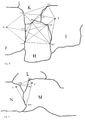
- FIG. 2 is a schematic map representation has explained in more detail.
- two neighboring ones are geographical limited areas, namely countries A and B.
- the map data for each of countries A and B are available on a separate CD.
- the Starting point S is in country A, while destination Z is in country B.
- the border points G1, G2 and G3 are common border points of countries A and B and hence the corresponding databases on the two CDs.
- the first step will be the first partial routes between the starting point S and the common limit points G1, G2 and G3 are calculated. To these three sub-routes the travel times are saved as route parameters.
- the destination Z contains, the partial routes between the destination Z and the common border points G1, G2 and G3 determined. They also become these three sub-routes Route parameters saved. Then, using the route parameters determines the optimal route between the starting point S and the destination Z.
- this can lead, for example, over the border location G1.
- This is then based on the map data that the starting point S included, the complete route between the starting point S and the selected one optimal limit point G1 fully calculated and the corresponding Route guidance information for the journey from starting point S to the border point G1 issued.
- the limit point G1 is reached, the CD changed and the entire route from border point G1 to Destination Z calculated. Then again the route guidance information until the destination Z is reached.
- FIG. 3 shows an example in which the starting point S and the destination Z not in neighboring countries.
- the starting point S is in country C, while The destination Z is in country E, with country D between countries C and E. lies.
- the map data for each of the countries C, D, E are on a separate one CD saved.
- To calculate the route between the starting point S and The destination Z is now proceeded so that the boundary points between the countries C and D, i.e. the border points G4, G5 and G6 as well the border points between the countries D and E, i.e. the border points G7, G8 and G9 can be determined.
- a search ellipse can be generated on the basis of this vector that limits the choice of border locations. This can an acceleration of the process can be achieved.
- the route parameters of the calculated partial routes then become optimal route, for example the route with the shortest travel time, from Start location to destination selected.
- the optimal Border locations set. For example, a route from Starting point S above border point G5 to border point G8 and from there to Point out destination Z as the optimal route so that the limit points G5 and G8 are hereby established.
- This is followed by a first step an exact route calculation from the starting point S to the border point G5 with the Map data of the CD for the country C.
- the border point G5 is reached then the CD is changed and the CD for country D is inserted, see above that route calculation takes place from the boundary point G5 to the boundary point G8 can.
- the CD is changed again and now inserted the CD with the map data of the country E, so that a route can be calculated from the boundary point G8 to the destination Z.
- this is the border point at G10 Country F, the border point G13 to country H and the border points G14 and G15 to country I.
- these are the border points G11 and G12 to country F, G13 to country K and G16 and G17 to country I.
- country I all boundary points to neighboring and existing as a database countries selected.
- FIG. 5 shows a further example in which the starting location S and the Destination Z in neighboring countries, namely countries N and M, are located Use of additional map data of a third country from Can be an advantage. Due to the geographical situation, a route can be taken from starting point S to destination Z through country L via border points G18 and G20 be cheaper than a trip across the common border between the countries N and M and the border point G19. Choosing the optimal route is done here based on three databases in a similar way as in context described with Figure 3.
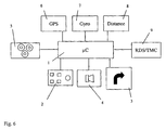
- the components of a motor vehicle navigation system are shown in FIG Implementation of the method according to the invention is shown schematically.
- the central component of the navigation system is the computing unit 1, which also contains the necessary storage elements.
- the computing unit 1 is one Control unit 2 connected via which, for example, the destination is entered or can be selected.
- the control unit 2 can be in the same housing as the computing unit 1 can be accommodated, but the control unit 2 can also be designed as a remote control, for example with the computing unit 1 is connected via an optical interface or a radio interface.
- An optical output unit 3 is connected to the computing unit 1, via which Route guidance information and other information are output. The Route guidance information can also be heard acoustically via a loudspeaker 4 be issued.
- the computing unit 1 is also equipped with a reader 5 connected, which reads the map data from a data carrier.
- the data carrier can be a CD, for example.
- the data carrier can be a CD, for example.
- the CD drive is a CD changer acts, since then several CDs can be inserted and the selection of the just needed CD can be done automatically.
- the control of the Drive 5 is carried out by the computing unit 1.
- Using the map data, that are stored on the CDs can be in the optimal route is calculated in the manner described above to which route guidance information is then provided via the optical output unit 3 can be spent.
- the navigation system also contains a receiver 6 for Reception of satellite navigation signals.
- the navigation system contains the ability to determine the position furthermore a direction sensor 7 and a displacement sensor 8, which also with the computing unit 1 are connected so that with the aid of a suitable computer program a position determination is possible with these signals.
- the computing unit 1 in the example shown is additionally equipped with a Broadcast receiver 9 connected to receive RDS / TMC signals is trained. This allows traffic information received from the radio receiver 9 forwarded to the computing unit 1 and for consideration are used in the route calculation.
Abstract
Description
Die Erfindung betrifft ein Verfahren zur Bestimmung einer Fahrtroute für ein Straßenfahrzeug zwischen einem Start- und einem Zielort unter Einbeziehung von mindestens zwei Datenbanken mit Landkartendaten. Weiterhin betrifft die Erfindung ein Navigationssystem eines Kraftfahrzeuges mit einer Recheneinheit zur Berechnung einer Route zwischen einem Start- und einem Zielort, einem mit der Recheneinheit verbundenen Lesegerät zum Auslesen von Landkartendaten aus einem Datenträger, Mitteln zur Bestimmung der Fahrzeugposition, einer mit der Recheneinheit verbundenen Eingabeeinheit und einer mit der Recheneinheit verbundenen Ausgabeeinheit.The invention relates to a method for determining a route for a Road vehicle between a start and a destination with inclusion of at least two databases with map data. Furthermore, the Invention a navigation system of a motor vehicle with a computing unit to calculate a route between a start and a destination, a reading device connected to the computing unit for reading map data from a data carrier, means for determining the vehicle position, an input unit connected to the computing unit and one with the Processing unit connected output unit.
Derartige Navigationssysteme sind bekannt und werden in Kraftfahrzeugen eingesetzt. Als Datenträger für die Landkartendaten dienen in der Regel CD-ROMs, so daß es sich bei dem Lesegerät um ein CD-Laufwerk handelt. Auf einer CD-ROM sind die Landkartendaten eines geographisch begrenzten Gebietes abgespeichert. Zumeist handelt es sich um die Landkartendaten eines bestimmten Landes. Ein Kraftfahrer, der über die Landesgrenzen hinausfährt, muß daher bei Überschreiten der Landesgrenze die CD-ROM wechseln, um weiterhin Zielführungsinformationen bis zu seinem gewünschten Zielort zu erhalten. Such navigation systems are known and are used in motor vehicles used. CD-ROMs are usually used as data carriers for the map data. so that the reader is a CD drive. On A CD-ROM is the map data of a geographically limited one Area saved. Mostly it is the map data of one certain country. A driver who crosses national borders must therefore change the CD-ROM when crossing the national border in order to continue to route guidance information to its desired destination receive.
Es sind auch bereits Systeme bekannt, die neben den Landkartendaten eines europäischen Landes auch das Fernstraßennetz von Europa enthalten. Wird hierbei das Land, das den Startort enthält, verlassen, so steht für die weitere Zielführung somit nur noch das Fernstraßennetz zur Verfügung. Dies hat zum einen zur Folge, daß eine Zielführung über Nebenstraßen, beispielsweise im Falle von Verkehrsbehinderungen auf den Fernstraßen, nicht möglich ist und weiterhin die Zielführung nur bis zu der dem Zielort nächstgelegenen Fernstraßenausfahrt möglich ist.Systems are also already known which, in addition to the map data, include a European country also include the trunk road network of Europe. Becomes leave the country that contains the starting location, it stands for the other Only the trunk road network is now available for route guidance. This has to one consequence that route guidance via secondary roads, for example in In case of traffic problems on the highways, is not possible and the route guidance continues only up to the highway exit closest to the destination is possible.
Aus der US 5,412,573 ist ein Navigationssystem bekannt, das mehrere Datenbanken in die Zielführung einbezieht. Hierbei handelt es sich jedoch einerseits um Datenbanken, die vollständige Informationen zur Zielführung enthalten, und andererseits um Datenbanken, die lediglich das Straßennetz ohne die für eine Zielführung erforderlichen Zusatzinformationen enthalten. Bei diesem bekannten System erfolgt daher eine Zielführung in bekannter Weise solange entsprechende Datenbankinformationen vorliegen und ein Umschalten in einen reinen Landkartenanzeigemodus, sobald ein Gebiet erreicht wird, zu dem eine Datenbank mit unvollständigen Informationen vorliegt.From US 5,412,573 a navigation system is known which has several databases involved in the route guidance. However, this is on the one hand databases that contain complete information on route guidance, and on the other hand, databases that only the road network without those for one Route guidance contain additional information required. In this well-known System therefore takes a route in a known manner as long as appropriate Database information is available and a switch to a pure one Map display mode as soon as an area to which a database is reached with incomplete information.
Aufgabe der Erfindung ist es, ein Verfahren zur Bestimmung einer Fahrtroute für ein Straßenfahrzeug zwischen einem Start- und einem Zielort anzugeben, wobei der Start- und Zielort in unterschiedlichen Datenbanken abgespeichert sind. Weiterhin ist es Aufgabe der Erfindung, ein Navigationssystem anzugeben, mit dem ein solches Verfahren besonders vorteilhaft ausgeführt werden kann.The object of the invention is a method for determining a route for a road vehicle between a start and a destination, where the start and destination are stored in different databases are. Furthermore, it is an object of the invention to provide a navigation system with which such a method is carried out particularly advantageously can be.
Die erstgenannte Aufgabe wird gelöst durch ein Verfahren zur Bestimmung einer Fahrtroute für ein Straßenfahrzeug zwischen einem Start- und einem Zielort unter Einbeziehung von mindestens zwei Datenbanken mit Landkartendaten zu benachbarten geographischen Gebieten durch Bestimmen von gemeinsamen Grenzpunkten von Datenbanken zu benachbarten geographischen Gebieten, Berechnen von ersten Teilrouten zwischen dem Startort und den gemeinsamen Grenzpunkten mit den Landkartendaten einer ersten Datenbank, die den Startort enthält, Abspeichern von Routenparametem zu den ersten Teilrouten, Berechnen von zweiten Teilrouten zwischen dem Zielort und den gemeinsamen Grenzpunkten mit den Landkartendaten einer zweiten Datenbank, die den Zielort enthält, Abspeichern von Routenparametern zu den zweiten Teilrouten, Auswählen einer Route zwischen dem Start- und Zielort anhand von Routenparametern der Gesamtroute, die sich aus Routenparametern der Teilrouten ergeben.The first-mentioned problem is solved by a method for determination a route for a road vehicle between a start and a Destination including at least two databases with map data to neighboring geographic areas by determining common boundary points from databases to neighboring geographical Areas, calculating the first partial routes between the starting point and the common border points with the map data of a first one Database containing the starting location, storing route parameters to the first partial routes, calculation of second partial routes between the destination and the common border points with the map data of a second Database containing the destination, storing route parameters to the second sub-routes, selecting a route between the start and destination based on route parameters of the overall route, which result from route parameters of the partial routes.
Mit dem erfindungsgemäßen Verfahren werden somit zunächst die Übergangsstellen (Grenzpunkte) von benachbarten geographischen Gebieten, deren Landkartendaten in verschiedenen Datenbanken abgespeichert sind, ermittelt. Decken die Datenbanken, die den Startort bzw. den Zielort enthalten, geographische Gebiete ab, die direkt aneinander grenzen, so ist es beispielsweise ausreichend nur einen Satz von Grenzpunkten zu bestimmen. In diesem Fall erfolgt eine Berechnung von ersten Teilrouten zwischen dem Startort und diesen Grenzpunkten und eine zweite Berechnung von Teilrouten zwischen dem Zielort und diesen Grenzpunkten. In beiden Fällen werden Routenparameter zu den Teilrouten abgespeichert und anhand der Routenparameter wird die optimale Route zwischen dem Start- und Zielort ermittelt. Bei den Routenparametern kann es sich insbesondere um die Fahrzeit oder die Fahrstrecke auf den Teilrouten handeln. Es ist jedoch auch möglich, die kompletten Zielführungsinformationen bereits in diesem Stadium abzuspeichern, wenn ausreichend Speicherkapazität zur Verfügung steht.With the inventive method, the transition points are thus first (Border points) of neighboring geographical areas whose Map data are stored in various databases. Cover the databases that contain the starting point or the destination, geographical Areas that directly adjoin each other, for example sufficient to determine only one set of limit points. In this case the first partial routes between the starting point and are calculated these limit points and a second calculation of partial routes between the destination and these border points. In both cases, route parameters for the partial routes and is saved based on the route parameters determines the optimal route between the start and destination. With the route parameters in particular, it can be the journey time or the distance traveled act on the sub-routes. However, it is also possible to have the complete route guidance information to be saved at this stage if sufficient Storage capacity is available.
Grenzen die geographische Gebiete, die den Start- und den Zielort enthalten, nicht unmittelbar aneinander, so müssen weitere Datenbanken zu weiteren geographischen Gebieten herangezogen werden, um eine Verbindung zwischen dem Start- und dem Zielort zu ermöglichen. In diesem Fall werden verschiedene Sätze von gemeinsamen Grenzpunkten von Datenbanken zu benachbarten geographischen Gebieten ermittelt. Beispielsweise werden dazu erste Teilrouten zwischen dem Startort und einem ersten Satz von Grenzpunkten ermittelt, die das geographische Gebiet, das den Startort enthält, mit einem benachbarten geographischen Gebiet verbinden. Ebenso werden zweite Teilrouten zwischen dem Zielort und einem zweiten Satz von Grenzpunkten berechnet, die Grenzpunkte zwischen dem geographischen Gebiet, das den Zielort enthält, und einem benachbarten geographischen Gebiet sind. Zusätzlich werden in einem solchen Fall weitere Teilrouten zwischen dem ersten Satz von Grenzpunkten und dem zweiten Satz von Grenzpunkten berechnet. Unter Umständen müssen hierbei, gegebenenfalls auch mehrfach, weitere gemeinsame Grenzpunkte zwischen benachbarten geographischen Gebieten bestimmt werden, zwischen denen Teilrouten berechnet werden.Boundaries the geographic areas that contain the start and the destination, not directly next to each other, further databases have to be added geographical areas are used to establish a connection between enable the start and the destination. In this case different sets of common boundary points of databases too neighboring geographic areas. For example first partial routes between the starting point and a first set of border points that determines the geographic area that contains the starting location with a connect neighboring geographic area. Likewise become second Sub-routes between the destination and a second set of border points calculates the boundary points between the geographic area that the Contains destination, and are a neighboring geographic area. In addition In such a case, further sub-routes between the first sentence of boundary points and the second set of boundary points. Under Circumstances may have to be shared, if necessary several times Boundary points between neighboring geographic areas are determined between which partial routes are calculated.
In einer Weitergestaltung der Erfindung werden erste Teilrouten zwischen dem Startort und allen Grenzpunkten berechnet, die die Datenbank, die den Startort enthält, zu allen weiteren verfügbaren Datenbanken aufweist. Das gleiche gilt für den Zielort. In diesem Fall werden beispielsweise auch bei Fahrten zwischen einem Start und einem Zielort, die in benachbarten Ländern liegen, Fahrtrouten in die Berechnung einbezogen, die Drittländer einbeziehen. Abhängig von der Lage des Start- und Zielortes und dem Grenzverlauf, kann dies zu kürzeren Fahrzeiten führen.In a further development of the invention, first partial routes between the Starting location and all limit points calculated by the database containing the starting location contains, to all other available databases. The same goes for for the destination. In this case, for example, when traveling between a start and a destination located in neighboring countries, driving routes included in the calculation that include third countries. Depends on the Location of the start and destination and the course of the border can shorten this Lead times.
Das Verfahren kann allgemein zur Routenplanung erfolgen, beispielsweise bereits vor Antritt der Fahrt an einem PC, es ist jedoch insbesondere zur Ausführung in einem Navigationssystem für Kraftfahrzeuge vorgesehen, In diesem Fall werden nach dem Auswählen einer Route anhand der Routenparameter zwischen dem Start- und Zielort Zielführungsinformationen ausgegeben. Sind die Datenbanken auf verschiedenen Datenträgern abgespeichert, was bei grenzüberschreitenden Fahrten in der Regel der Fall sein wird, so ist vorzugsweise vorgesehen, daß der Wechsel der Datenträger automatisch erfolgt. Handelt es sich bei den Datenträgern um CD-ROMs, so wird hierbei als Lesegerät ein CD-Wechsler bevorzugt. In diesem Fall entfällt das manuelle Einlegen weiterer CD-ROMs.The method can generally be used for route planning, for example even before starting the trip on a PC, but it is especially for Execution provided in a navigation system for motor vehicles, In In this case, after selecting a route based on the route parameters Route guidance information is output between the start and destination. If the databases are stored on different data carriers, which is usually the case with cross-border journeys preferably provided that the change of disk automatically he follows. If the data carriers are CD-ROMs, then this is called Reader preferred a CD changer. In this case there is no manual Insert additional CD-ROMs.
Ein erfindungsgemäßes Navigationssystem ist daher dadurch gekennzeichnet, daß das Lesegerät zur Aufnahme von mehreren wechselbaren Datenträgern, sowie zum wahlweisen Auslesen von Daten aus einem der Datenträger ausgebildet ist und die Routenberechnung unter Einbeziehung von Landkartendaten erfolgt, die auf mehreren Datenträgern abgespeichert sind.A navigation system according to the invention is therefore characterized in that that the reader for holding several exchangeable data carriers, as well as for selectively reading out data from one of the data carriers is and the route calculation including map data takes place, which are stored on several data carriers.
Die Erfindung wird nachfolgend anhand von Ausführungsbeispielen und der Zeichnung näher erläutert. Es zeigen:
Figur 1- ein Ablaufdiagramm eines erfindungsgemäßen Verfahrens
Figur 2- eine schematische Landkartendarstellung zur Routenberechnung
nach dem Ablaufdiagramm gemäß
Figur 1 Figur 3- eine schematische Landkartendarstellung zur Routenberechnung unter Einbeziehung von drei Datenbanken
Figur 4- eine schematische Landkartendarstellung zur Routenberechnung unter Einbeziehung von vier Datenbanken
Figur 5- eine schematische Landkartendarstellung zur Routenberechnung bei Fahrt in ein benachbartes Land unter Einbeziehung eines Drittlandes.
- Figure 1
- a flowchart of a method according to the invention
- Figure 2
- 2 shows a schematic map representation for route calculation according to the flow chart according to FIG. 1
- Figure 3
- is a schematic map representation for route calculation including three databases
- Figure 4
- is a schematic map representation for route calculation including four databases
- Figure 5
- is a schematic map representation for route calculation when driving to a neighboring country including a third country.
In den nachfolgenden Ausführungsbeispielen wird davon ausgegangen, daß die Landkartendaten zu jeweils einem Land in einer Datenbank auf einer CD-ROM abgespeichert sind. Ein geographisches Gebiet ist somit identisch mit einem Land. Dies stellt jedoch keine Beschränkung der Erfindung dar. Vielmehr kann die Erfindung für allgemeine geographische Gebiete eingesetzt werden, die nicht durch Ländergrenzen begrenzt sein müssen.In the following exemplary embodiments it is assumed that the Map data for each country in a database on a CD-ROM are saved. A geographic area is therefore identical to one Country. However, this is not a limitation of the invention. Rather, it can the invention can be used for general geographic areas that do not have to be limited by national borders.
Figur 1 zeigt ein Ablaufdiagramm eines erfindungsgemäßen Verfahrens für eine Routenberechnung über zwei Datenbanken. In Schritt S1 werden der Start- und der Zielort vorgegeben. Dies kann beispielsweise dadurch geschehen, daß beide direkt über eine Eingabeeinheit eingegeben werden, Im Falle eines Navigationssystems ist es jedoch auch möglich, daß der Startort als die gegenwärtige Position des Fahrzeuges automatisch, beispielsweise über Satellitennavigation bestimmt wird und lediglich der Zielort eingegeben oder aus einer Liste ausgewählt wird. In Schritt S2 wird anschließend geprüft, ob der Start- und der Zielort auf der ersten CD-ROM (nachfolgend abgekürzt CD) vorhanden ist. Ist dies der Fall, so kann in Schritt S2a direkt in bekannter Weise die Routenberechnung erfolgen und anschließend werden die Zielführungsinformationen zu der berechneten Route ausgegeben (Schritt S2b). Wird in Schritt S2 festgestellt, daß der Start- und/oder Zielort nicht auf der ersten CD vorhanden ist, so wird die CD gewechselt (Schritt S3) und es wird in Schritt S4 geprüft, ob der Start- und/oder Zielort auf der zweiten CD vorhanden sind. Sind sowohl der Start- und Zielort auf der zweiten CD vorhanden, so erfolgt wie oben bereits beschrieben in Schritt S2a die Routenberechnung und nachfolgend die Ausgabe der Zielführungsinformationen in Schritt S2b.Figure 1 shows a flow chart of a method according to the invention for a Route calculation via two databases. In step S1, the start and the destination is given. This can happen, for example, in that both are entered directly via an input unit, in the case of a Navigation system, it is also possible that the starting point as the current position of the vehicle automatically, for example via Satellite navigation is determined and only the destination entered or off selected from a list. It is then checked in step S2 whether the Start and destination on the first CD-ROM (hereinafter abbreviated CD) is available. If this is the case, then step S2a can be carried out directly in a known manner The route calculation is done and then the route guidance information output to the calculated route (step S2b). Is in Step S2 determined that the start and / or destination is not on the first CD is present, the CD is changed (step S3) and it is in step S4 checked whether the start and / or destination are available on the second CD. are Both the start and destination are available on the second CD, as above already described in step S2a the route calculation and subsequently the Output of the route guidance information in step S2b.
Die nachfolgende Beschreibung des Verfahrens geht davon aus, daß nur zwei CDs vorhanden sind und daß auf der einen CD der Startort und auf der anderen CD der Zielort abgespeichert ist. Kann zumindest einer dieser Orte auf keiner der beiden CDs gefunden werden, so wird eine Fehlermeldung ausgegeben. Ansonsten werden in Schritt S5 alle Grenzpunkte der zweiten CD in das System eingelesen. Anschließend wird in Schritt S6 die CD gewechselt, so daß nunmehr wiederum die erste CD zur Verfügung steht. Auch von dieser CD werden alle Grenzpunkte eingelesen (Schritt S7). Anschließend werden in Schritt S8 die gemeinsamen Grenzpunkte ausgewählt.The following description of the method assumes that only two CDs are available and that on one CD the starting point and on the other CD the destination is saved. Can at least one of these places on none of the two CDs are found, an error message is output. Otherwise, all limit points of the second CD are in step S5 in the System read. The CD is then changed in step S6, so that now the first CD is available again. Also from this CD all limit points are read in (step S7). Then in Step S8 selected the common boundary points.
Bei dem in Figur 1 a dargestellten Teilverfahren wird davon ausgegangen, daß in der Mehrzahl der Routenberechnungen der Start- und der Zielort auf einer CD abgespeichert sein werden. Deshalb erfolgt in Schritt S2 bzw. S4 die Abfrage, ob Start- und Zielort auf einer CD vorhanden sind, und zwischen Schritt S2 und S4 wird in Schritt S3 aus Zeitgründen lediglich die CD gewechselt. Alternativ hierzu können auch bereits nach dem Schritt S2 die Grenzpunkte von der ersten CD eingelesen werden. In diesem Falle entfallen die Schritte S5 und S6. Nachteilig ist die etwas längere Zeit zwischen der Ausführung der Schritte S2 und S4.In the partial process shown in Figure 1 a it is assumed that in the majority of route calculations, the start and the destination are on one CD will be saved. That is why the step S2 or S4 Query whether the start and destination are on a CD and between For reasons of time, steps S2 and S4 in step S3 only the CD is changed. As an alternative to this, the limit points can also be set after step S2 read from the first CD. In this case, the Steps S5 and S6. The somewhat longer time between execution is disadvantageous of steps S2 and S4.
In Figur 1b ist der weitere Ablauf des Verfahrens nach Auswahl der gemeinsamen
Grenzpunkte in Schritt S8 dargestellt. In Schritt S9 erfolgt nunmehr die
Routenplanung zwischen dem Start- bzw. Zielort und den Grenzpunkten, je
nach dem welcher der beiden Orte auf der gerade aktuell eingelegten CD
vorhanden ist. Zu den berechneten Routen werden anschließend in Schritt S10
Routenparameter, wie beispielsweise die Fahrtzeit oder die Fahrtstrecke
abgespeichert. Anschließend wird in Schritt S11 die CD gewechselt und in
Schritt S12 die Routenplanung zwischen dem Ziel- bzw. Startort und den
Grenzpunkten durchgeführt, je nach dem, mit welchem der beiden Orte noch
keine Berechnungen erfolgt sind. Auch zu diesen Routen werden in Schritt S13
Routenparameter abgespeichert. Anhand der Routenparameter erfolgt dann die
Bestimmung der optimalen Route zwischen dem Start- und dem Zielort und
damit auch die Auswahl des optimalen Grenzpunktes (Schritt S14). Anschließend
wird in Schritt S15 geprüft, ob die aktuell eingelegte CD den Startort
enthält. Ist dies der Fall, so wird in Schritt S17 die Routenberechnung zwischen
dem Startort und dem ausgewählten optimalen Grenzpunkt durchgeführt.
Enthält in Schritt S15 die CD nicht den Startort, so wird zuvor in Schritt S16 die
CD gewechselt. Nach Berechnung der genauen Route zwischen dem Startort
und dem Grenzpunkt in Schritt S17 wird anschließend in S18 die Zielführungsinformation
an den Fahrzeugführer ausgegeben. In Schritt S19 wird überprüft,
ob der Grenzpunkt inzwischen erreicht wurde. Ist dies nicht der Fall, so werden
weiterhin die Zielführungsinformationen in Schritt 18 ausgegeben. Wird dagegen
in Schritt 19 festgestellt, daß der Grenzpunkt erreicht wurde, so wird
anschließend in Schritt S20 die CD gewechselt und in Schritt S21 die Routenberechnung
zwischen dem ausgewählten optimalen Grenzpunkt und dem
Zielort durchgeführt. Anschließend werden die Zielführungsinformationen für die
zweite Teilstrecke zwischen dem Grenzpunkt und dem Zielort ausgegeben.FIG. 1b shows the further course of the method after the common one has been selected
Limit points shown in step S8. The step S9 now takes place
Route planning between the start or destination and the border points, each
according to which of the two places on the currently inserted CD
is available. The calculated routes are then in step S10
Route parameters, such as the travel time or the route
saved. The CD is then changed in step S11 and in
Step S12 the route planning between the destination or start location and
Boundary points carried out, depending on which of the two places still
no calculations have been made. These routes are also in step S13
Route parameters saved. The route parameters are then used
Determination of the optimal route between the start and the destination and
thus also the selection of the optimal limit point (step S14). Subsequently
it is checked in step S15 whether the currently inserted CD is the starting location
contains. If this is the case, the route calculation is between in step S17
the starting point and the selected optimal limit point.
If the CD does not contain the start location in step S15, then in step S16
CD changed. After calculating the exact route between the starting point
and the limit point in step S17 then becomes the route guidance information in S18
issued to the driver. In step S19 it is checked whether
whether the border point has been reached. If not, so be it
the route guidance information is also output in
Weist das Navigationssystem ausreichend Speicherplatz auf, so daß bereits in den Schritten S10 und S13 die komplette Zielführungsinformation als Routenparameter abgespeichert werden kann, so können die Schritte S15 bis S21 entfallen.If the navigation system has sufficient storage space, so that already in steps S10 and S13 the complete route guidance information as route parameters can be stored, steps S15 to S21 omitted.
Der in Zusammenhang mit Figur 1 beschriebene Verfahrensablauf wird nachfolgend anhand der Figur 2, die eine schematische Landkartendarstellung aufweist, noch näher erläutert. In Figur 2 sind zwei benachbarte geographisch begrenzte Gebiete, nämlich die Länder A und B, dargestellt. Die Landkartendaten zu jedem der Länder A und B liegen auf einer separaten CD vor. Der Startort S liegt im Land A, während der Zielort Z im Land B liegt. Die Grenzpunkte G1, G2 und G3 sind gemeinsame Grenzpunkte der Länder A und B und somit auch der entsprechenden Datenbanken auf den beiden CDs. In einem ersten Schritt werden erste Teilrouten zwischen dem Startort S und den gemeinsamen Grenzpunkten G1, G2 und G3 berechnet. Zu diesen drei Teilrouten werden als Routenparameter die Fahrzeiten abgespeichert. Anschließend werden mit den Landkartendaten der zweiten CD, die den Zielort Z enthält, die Teilrouten zwischen dem Zielort Z und den gemeinsamen Grenzpunkten G1, G2 und G3 bestimmt. Auch zu diesen drei Teilrouten werden die Routenparameter abgespeichert. Anschließend wird anhand der Routenparameter die optimale Route zwischen dem Startort S und dem Zielort Z bestimmt. The procedure described in connection with Figure 1 is as follows with reference to Figure 2, which is a schematic map representation has explained in more detail. In Figure 2, two neighboring ones are geographical limited areas, namely countries A and B. The map data for each of countries A and B are available on a separate CD. The Starting point S is in country A, while destination Z is in country B. The border points G1, G2 and G3 are common border points of countries A and B and hence the corresponding databases on the two CDs. In one The first step will be the first partial routes between the starting point S and the common limit points G1, G2 and G3 are calculated. To these three sub-routes the travel times are saved as route parameters. Subsequently are with the map data of the second CD, the destination Z contains, the partial routes between the destination Z and the common border points G1, G2 and G3 determined. They also become these three sub-routes Route parameters saved. Then, using the route parameters determines the optimal route between the starting point S and the destination Z.
Im dargestellten Fall kann diese zum Beispiel über den Grenzort G1 führen. Daran anschließend wird anhand der Landkartendaten, die den Startort S enthalten, die komplette Route zwischen dem Startort S und dem ausgewählten optimalen Grenzpunkt G1 vollständig berechnet und es werden die entsprechenden Zielführungsinformationen für die Fahrt vom Startort S zum Grenzpunkt G1 ausgegeben. Bei Erreichen des Grenzpunktes G1 wird die CD gewechselt und es wird die komplette Fahrtroute vom Grenzpunkt G1 zum Zielort Z berechnet. Anschließend werden wiederum die Zielführungsinformationen bis zum Erreichen des Zielortes Z ausgegeben.In the case shown, this can lead, for example, over the border location G1. This is then based on the map data that the starting point S included, the complete route between the starting point S and the selected one optimal limit point G1 fully calculated and the corresponding Route guidance information for the journey from starting point S to the border point G1 issued. When the limit point G1 is reached, the CD changed and the entire route from border point G1 to Destination Z calculated. Then again the route guidance information until the destination Z is reached.
In Figur 3 ist ein Beispiel dargestellt, bei dem der Startort S und der Zielort Z nicht in benachbarten Ländern liegen. Der Startort S liegt im Land C, während der Zielort Z im Land E liegt, wobei zwischen den Ländern C und E das Land D liegt. Die Landkartendaten zu jedem der Länder C, D, E sind auf einer separaten CD abgespeichert. Zur Berechnung der Route zwischen dem Startort S und dem Zielort Z wird nun so vorgegangen, daß zunächst die Grenzpunkte zwischen den Ländern C und D, das heißt die Grenzpunkte G4, G5 und G6 sowie die Grenzpunkte zwischen den Ländern D und E, das heißt die Grenzpunkte G7, G8 und G9 bestimmt werden. Anschließend werden in einem ersten Schritt Routen zwischen dem Startort S und den Grenzpunkten G4, G5 und G6 berechnet und die Routenparameter zu diesen abgespeichert. In einem zweiten Schritt werden die Routen zwischen dem Zielort Z und den Grenzorten G7, G8 und G9 berechnet und ebenfalls die Routenparameter abgespeichert. Nachfolgend werden weitere Teilrouten zwischen den Grenzorten G4, G5 und G6, die Grenzorte zwischen den Ländern C und D sind, und den Grenzorten G7, G8 und G9, die Grenzorte zwischen den Ländern D und E sind, berechnet. Die Reihenfolge der Berechnung der Teilrouten kann vertauscht werden.FIG. 3 shows an example in which the starting point S and the destination Z not in neighboring countries. The starting point S is in country C, while The destination Z is in country E, with country D between countries C and E. lies. The map data for each of the countries C, D, E are on a separate one CD saved. To calculate the route between the starting point S and The destination Z is now proceeded so that the boundary points between the countries C and D, i.e. the border points G4, G5 and G6 as well the border points between the countries D and E, i.e. the border points G7, G8 and G9 can be determined. Then in a first step Routes between the starting point S and the border points G4, G5 and G6 calculated and the route parameters for these saved. In a second The routes between the destination Z and the border locations G7, G8 become step and G9 are calculated and the route parameters are also stored. Below are further sub-routes between the border towns G4, G5 and G6, the Border locations between countries C and D are, and the border locations G7, G8 and G9, which are border towns between countries D and E, are calculated. The The order of calculating the partial routes can be interchanged.
Sofern durch die entsprechenden Informationen in den Datenbanken unterstützt, kann auch ein Luftlinienvektor des Zielortes in Bezug zum Startort ermittelt werden. Aufgrund dieses Vektors kann eine Suchellipse generiert werden, die die Auswahl von Grenzorten räumlich einschränkt. Hierdurch kann eine Beschleunigung des Verfahrens erreicht werden.If supported by the relevant information in the databases, can also be an air line vector of the destination in relation to the starting point be determined. A search ellipse can be generated on the basis of this vector that limits the choice of border locations. This can an acceleration of the process can be achieved.
Aus den Routenparametern der berechneten Teilrouten wird anschließend die optimale Route, beispielsweise die Route mit der kürzesten Fahrtzeit, vom Startort zum Zielort ausgewählt. Hierdurch werden gleichzeitig die optimalen Grenzorte festgelegt. Beispielsweise kann sich hierbei eine Fahrtroute vom Startort S über dem Grenzpunkt G5 zum Grenzpunkt G8 und von dort zum Zielort Z als optimale Route herausstellen, so daß die Grenzpunkte G5 und G8 hiermit festgelegt sind. Anschließend erfolgt wiederum in einem ersten Schritt eine genaue Routenberechnung vom Startort S zum Grenzpunkt G5 mit den Landkartendaten der CD für das Land C. Bei Erreichen des Grenzpunktes G5 wird anschließend die CD gewechselt und die CD für das Land D eingelegt, so daß eine Routenberechnung vom Grenzpunkt G5 zum Grenzpunkt G8 erfolgen kann. Nach Erreichen des Grenzpunktes G8 wird wiederum die CD gewechselt und nunmehr die CD mit den Landkartendaten des Landes E eingelegt, so daß eine Routenberechnung vom Grenzpunkt G8 zum Zielort Z erfolgen kann.The route parameters of the calculated partial routes then become optimal route, for example the route with the shortest travel time, from Start location to destination selected. As a result, the optimal Border locations set. For example, a route from Starting point S above border point G5 to border point G8 and from there to Point out destination Z as the optimal route so that the limit points G5 and G8 are hereby established. This is followed by a first step an exact route calculation from the starting point S to the border point G5 with the Map data of the CD for the country C. When the border point G5 is reached then the CD is changed and the CD for country D is inserted, see above that route calculation takes place from the boundary point G5 to the boundary point G8 can. After reaching the limit point G8, the CD is changed again and now inserted the CD with the map data of the country E, so that a route can be calculated from the boundary point G8 to the destination Z.
In Figur 4 ist eine Situation dargestellt, bei der Landkartendaten der Routenberechnung zugrundegelegt werden, die für vier verschiedene Länder auf vier verschiedenen CDs abgelegt sind. Es handelt sich hierbei um die Länder F, H, K und I, wobei der Startort S im Land F und der Zielort Z im Land I liegt. Die Länder F und I weisen keine gemeinsame Grenze auf, vielmehr befinden sich zwischen diesen beiden Ländern die Länder K und H. Ausgehend vom Startort S werden nun Routen zu allen Grenzpunkten berechnet, die die Datenbank zum Land F zu allen sonstigen vorhandenen Datenbanken aufweist. In diesem Fall sind dies die Datenbanken für die Länder K und H, so daß die Grenzpunkte G10, G11 und G12 ausgewählt werden. Auch für die Länder K und H werden alle Grenzpunkte zu solchen Ländern ausgewählt, zu denen Datenbankinformationen vorliegen. Im Falle des Landes K sind dies der Grenzpunkt G10 zum Land F, der Grenzpunkt G13 zum Land H und die Grenzpunkte G14 und G15 zum Land I. Im Falle des Landes H sind dies die Grenzpunkte G11 und G12 zum Land F, G13 zu Land K und G16 und G17 zum Land I. Auch für das Land I werden alle Grenzpunkte zu den benachbarten und als Datenbank vorhandenen Ländern ausgewählt. Anschließend werden in einem ersten Schritt erste Teilrouten zwischen dem Startort und allen Grenzpunkten, die das Land des Startortes mit den benachbarten Ländern, zu denen Datenbankinformationen vorliegen, aufweist, berechnet. Dies sind die Routen zwischen dem Startort S und den Grenzpunkten G10, G11 und G12. In gleicher Weise werden für den Zielort zweite Teilrouten zu den Grenzpunkten G14, G15, G16 und G17 berechnet. Zusätzlich werden für die Datenbank zum Land K Teilrouten zwischen den Grenzpunkten G10, G13, G14 und G15, sowie für das Land H Teilrouten zwischen den Grenzpunkten G11, G12, G13, G16 und G17 berechnet. Zu allen Teilrouten werden, wie zuvor bereits beschrieben, entsprechende Routenparameter abgespeichert. Anhand der Routenparameter wird anschließend die optimale Route vom Startort S zum Zielort Z bestimmt, die beispielsweise über die Grenzpunkte G11 und G16 führen kann. Die vollständige Berechnung der Fahrtroute und die Ausgabe der Zielführungsinformationen erfolgt dann in ähnlicher Weise wie in Zusammenhang mit Figur 3 beschrieben mit den Datenbanken zu den Ländern F, H und I.In Figure 4, a situation is shown in the map data of the route calculation be based on four for four different countries various CDs are stored. These are the countries F, H, K and I, with the starting point S in country F and the destination Z in country I. The Countries F and I do not have a common border, rather they are between these two countries the countries K and H. Starting from the starting point S routes are now calculated to all limit points that the database to country F to all other existing databases. In this The case is the databases for the countries K and H, so that the border points G10, G11 and G12 can be selected. Also for the countries K and H. all border points to countries selected for which database information available. In the case of country K, this is the border point at G10 Country F, the border point G13 to country H and the border points G14 and G15 to country I. In the case of country H these are the border points G11 and G12 to country F, G13 to country K and G16 and G17 to country I. Also for country I all boundary points to neighboring and existing as a database Countries selected. Then, in a first step, the first Sub-routes between the starting point and all border points that the country of the Starting point with the neighboring countries, to which database information available, has, calculated. These are the routes between the starting point S and the limit points G10, G11 and G12. In the same way for the Destination second sub-routes to the border points G14, G15, G16 and G17 calculated. In addition, for the country database K partial routes between the border points G10, G13, G14 and G15, as well as for the country H Sub-routes calculated between the boundary points G11, G12, G13, G16 and G17. Corresponding to all sub-routes, as already described above Route parameters saved. Based on the route parameters is then determines the optimal route from the starting point S to the destination Z, for example over the limit points G11 and G16. The complete one Calculation of the route and the output of route guidance information is then carried out in a manner similar to that described in connection with FIG. 3 with the databases for the countries F, H and I.
In Figur 5 ist ein weiteres Beispiel dargestellt, in dem der Startort S und der Zielort Z in benachbarten Ländern, nämlich den Ländern N und M, liegen, die Heranziehung von zusätzlichen Landkartendaten eines Drittlandes jedoch von Vorteil sein kann. Aufgrund der geographischem Situation kann eine Fahrtroute vom Startort S zum Zielort Z durch das Land L über die Grenzpunkte G18 und G20 günstiger sein, als eine Fahrt über die gemeinsame Grenze zwischen den Ländern N und M und den Grenzpunkt G19. Die Auswahl der optimalen Route erfolgt hier aufgrund von drei Datenbanken in ähnlicher Weise wie in Zusammenhang mit Figur 3 beschrieben. FIG. 5 shows a further example in which the starting location S and the Destination Z in neighboring countries, namely countries N and M, are located Use of additional map data of a third country from Can be an advantage. Due to the geographical situation, a route can be taken from starting point S to destination Z through country L via border points G18 and G20 be cheaper than a trip across the common border between the Countries N and M and the border point G19. Choosing the optimal route is done here based on three databases in a similar way as in context described with Figure 3.
In Figur 6 sind die Komponenten eines Kraftfahrzeug-Navigationssystems zur
Durchführung des erfindungsgemäßen Verfahrens schematisch dargestellt.
Zentraler Bestandteil des Navigationssystems ist die Recheneinheit 1, die auch
die erforderlichen Speicherelemente enthält. Mit der Recheneinheit 1 ist eine
Bedieneinheit 2 verbunden, über die beispielsweise der Zielort eingegeben oder
ausgewählt werden kann. Die Bedieneinheit 2 kann im gleichen Gehäuse wie
die Recheneinheit 1 untergebracht sein, jedoch kann die Bedieneinheit 2 auch
als Fernbedienung ausgebildet sein, die mit der Recheneinheit 1 beispielsweise
über eine optische Schnittstelle oder eine Funkschnittstelle in Verbindung steht.
Mit der Recheneinheit 1 ist eine optische Ausgabeeinheit 3 verbunden, über die
Zielführungsinformationen und sonstige Informationen ausgegeben werden. Die
Zielführungsinformationen können weiterhin über einen Lautsprecher 4 akustisch
ausgegeben werden. Die Recheneinheit 1 ist ferner mit einem Lesegerät 5
verbunden, das die Landkartendaten von einem Datenträger ausliest. Bei dem
Datenträger kann es sich beispielsweise um eine CD handeln. In diesem Fall
enthält das Navigationssystem als Lesegerät 5 ein CD-Laufwerk. Besonders
vorteilhaft ist es, wenn es sich bei dem CD-Laufwerk um einen CD-Wechsler
handelt, da dann mehrere CDs eingelegt werden können und die Auswahl der
gerade benötigten CD automatisiert erfolgen kann. Die Ansteuerung des
Laufwerkes 5 erfolgt dabei durch die Recheneinheit 1. Anhand der Landkartendaten,
die auf den CDs abgelegt sind, kann bei bekanntem Start- und Zielort in
der zuvor beschriebenen Weise eine Berechnung der optimalen Route durchgeführt
werden, zu der dann über die optische Ausgabeeinheit 3 Zielführungsinformationen
ausgegeben werden können. Zur Bestimmung der aktuellen
Fahrzeugposition enthält das Navigationssystem ferner einen Empfänger 6 zum
Empfang von Satellitennavigationssignalen. Um eine von Satelliten unabhängige
Positionsbestimmung durchführen zu können, enthält das Navigationssystem
ferner einen Richtungssensor 7 und einen Wegsensor 8, die ebenfalls mit
der Recheneinheit 1 verbunden sind, so daß mit Hilfe eines geeigneten Computerprogramms
mit diesen Signalen eine Positionsbestimmung möglich ist.
Ferner ist die Recheneinheit 1 im dargestellten Beispiel zusätzlich mit einem
Rundfunkempfänger 9 verbunden, der zum Empfang von RDS/TMC-Signalen
ausgebildet ist. Somit können empfangene Verkehrsinformationen vom Rundfunkempfänger
9 an die Recheneinheit 1 weitergeleitet und zur Berücksichtigung
bei der Routenberechnung herangezogen werden.The components of a motor vehicle navigation system are shown in FIG
Implementation of the method according to the invention is shown schematically.
The central component of the navigation system is the
Das erfindungsgemäße Verfahren und ein zur Durchführung des Verfahrens besonders geeignetes Navigationssystem wurden anhand von Ausführungsbeispielen beschrieben. Abwandlungen hierzu sind möglich, ohne den Grundgedanken der Erfindung zu verlassen. Insbesondere ist es möglich, die Reihenfolge der Verfahrensschritte zur Berechnung der einzelnen Teilrouten abzuändern.The method according to the invention and one for carrying out the method Particularly suitable navigation systems were based on exemplary embodiments described. Modifications to this are possible without the basic idea to leave the invention. In particular, it is possible to change the order of the procedural steps for calculating the individual partial routes.
Claims (15)
dadurch gekennzeichnet,
daß das Lesegerät (5) zur Aufnahme von mehreren wechselbaren Datenträgern sowie zum wahlweisen Auslesen von Daten aus einem der Datenträger ausgebildet ist und die Routenberechnung unter Einbeziehung von Landkartendaten erfolgt, die auf mehreren Datenträgern abgespeichert sind.
characterized,
that the reading device (5) is designed to receive a plurality of exchangeable data carriers and to selectively read out data from one of the data carriers and the route is calculated with the inclusion of map data which are stored on a plurality of data carriers.
Applications Claiming Priority (2)
| Application Number | Priority Date | Filing Date | Title |
|---|---|---|---|
| DE19947789 | 1999-10-05 | ||
| DE1999147789 DE19947789A1 (en) | 1999-10-05 | 1999-10-05 | Method for determining a route for a road vehicle |
Publications (1)
| Publication Number | Publication Date |
|---|---|
| EP1092950A1 true EP1092950A1 (en) | 2001-04-18 |
Family
ID=7924465
Family Applications (1)
| Application Number | Title | Priority Date | Filing Date |
|---|---|---|---|
| EP00120432A Withdrawn EP1092950A1 (en) | 1999-10-05 | 2000-09-19 | Method to determine route for road vehicle |
Country Status (2)
| Country | Link |
|---|---|
| EP (1) | EP1092950A1 (en) |
| DE (1) | DE19947789A1 (en) |
Cited By (5)
| Publication number | Priority date | Publication date | Assignee | Title |
|---|---|---|---|---|
| WO2006018337A1 (en) * | 2004-08-14 | 2006-02-23 | Robert Bosch Gmbh | Navigation method |
| CN100335862C (en) * | 2003-05-14 | 2007-09-05 | 行毅科技股份有限公司 | Cross-country navigation system |
| US7596542B1 (en) * | 2004-05-25 | 2009-09-29 | Allstate Insurance Company | Systems and methods for creating geographic connection matrices |
| EP2273231A1 (en) * | 2008-04-28 | 2011-01-12 | Navitime Japan Co., Ltd. | Route guidance system, route search server, route guidance method, and terminal |
| GB2505464A (en) * | 2012-08-31 | 2014-03-05 | Bae Systems Plc | Iterative route planning using a pre-determined seed-set of optimal routes |
Families Citing this family (3)
| Publication number | Priority date | Publication date | Assignee | Title |
|---|---|---|---|---|
| TW200424963A (en) * | 2003-05-02 | 2004-11-16 | Sin Etke Technology Co Ltd | Cross country navigation system |
| JP4420471B1 (en) * | 2008-11-07 | 2010-02-24 | 株式会社ナビタイムジャパン | Route guidance mediation system, route guidance mediation server, and route guidance method |
| DE102011113419A1 (en) | 2011-09-15 | 2013-03-21 | GM Global Technology Operations LLC (n. d. Gesetzen des Staates Delaware) | A method for determining a route running between an initial location and an end location, taking into account area conditions of different areas, route planning device and motor vehicle |
Citations (5)
| Publication number | Priority date | Publication date | Assignee | Title |
|---|---|---|---|---|
| JPH037983A (en) * | 1989-06-05 | 1991-01-16 | Alpine Electron Inc | Changing method for storage medium for map |
| JPH0546090A (en) * | 1991-08-15 | 1993-02-26 | Sony Corp | Information retrieval system and navigation system |
| US5412573A (en) * | 1993-05-20 | 1995-05-02 | Motorola Inc. | Multi-mode route guidance system and method therefor |
| EP0726447A1 (en) * | 1995-02-09 | 1996-08-14 | Zexel Corporation | Incremental route calculation |
| EP0798539A2 (en) * | 1996-03-29 | 1997-10-01 | Sanyo Electric Co. Ltd | Navigation device |
Family Cites Families (2)
| Publication number | Priority date | Publication date | Assignee | Title |
|---|---|---|---|---|
| US5220507A (en) * | 1990-11-08 | 1993-06-15 | Motorola, Inc. | Land vehicle multiple navigation route apparatus |
| JP3411763B2 (en) * | 1996-09-10 | 2003-06-03 | アルパイン株式会社 | Navigation device |
-
1999
- 1999-10-05 DE DE1999147789 patent/DE19947789A1/en not_active Withdrawn
-
2000
- 2000-09-19 EP EP00120432A patent/EP1092950A1/en not_active Withdrawn
Patent Citations (5)
| Publication number | Priority date | Publication date | Assignee | Title |
|---|---|---|---|---|
| JPH037983A (en) * | 1989-06-05 | 1991-01-16 | Alpine Electron Inc | Changing method for storage medium for map |
| JPH0546090A (en) * | 1991-08-15 | 1993-02-26 | Sony Corp | Information retrieval system and navigation system |
| US5412573A (en) * | 1993-05-20 | 1995-05-02 | Motorola Inc. | Multi-mode route guidance system and method therefor |
| EP0726447A1 (en) * | 1995-02-09 | 1996-08-14 | Zexel Corporation | Incremental route calculation |
| EP0798539A2 (en) * | 1996-03-29 | 1997-10-01 | Sanyo Electric Co. Ltd | Navigation device |
Non-Patent Citations (2)
| Title |
|---|
| PATENT ABSTRACTS OF JAPAN vol. 015, no. 119 (P - 1183) 22 March 1991 (1991-03-22) * |
| PATENT ABSTRACTS OF JAPAN vol. 017, no. 341 (P - 1565) 28 June 1993 (1993-06-28) * |
Cited By (16)
| Publication number | Priority date | Publication date | Assignee | Title |
|---|---|---|---|---|
| CN100335862C (en) * | 2003-05-14 | 2007-09-05 | 行毅科技股份有限公司 | Cross-country navigation system |
| US8321472B1 (en) | 2004-05-25 | 2012-11-27 | Allstate Insurance Company | Systems and methods for creating geographic connection matrices |
| US7596542B1 (en) * | 2004-05-25 | 2009-09-29 | Allstate Insurance Company | Systems and methods for creating geographic connection matrices |
| US7769609B1 (en) | 2004-05-25 | 2010-08-03 | Allstate Insurance Company | Systems and methods for determining territorial rates |
| US8996576B1 (en) * | 2004-05-25 | 2015-03-31 | Allstate Insurance Company | Systems and methods for creating geographic connection matrices |
| US8612484B1 (en) | 2004-05-25 | 2013-12-17 | Allstate Insurance Company | Systems and methods for creating geographic connection matrices |
| WO2006018337A1 (en) * | 2004-08-14 | 2006-02-23 | Robert Bosch Gmbh | Navigation method |
| EP2273231A1 (en) * | 2008-04-28 | 2011-01-12 | Navitime Japan Co., Ltd. | Route guidance system, route search server, route guidance method, and terminal |
| US8200432B2 (en) | 2008-04-28 | 2012-06-12 | Navitime Japan Co., Ltd. | Route guidance system, route search server, route guidance method, and terminal |
| EP2273231A4 (en) * | 2008-04-28 | 2011-05-04 | Navitime Japan Co Ltd | Route guidance system, route search server, route guidance method, and terminal |
| GB2505464A (en) * | 2012-08-31 | 2014-03-05 | Bae Systems Plc | Iterative route planning using a pre-determined seed-set of optimal routes |
| WO2014033444A1 (en) * | 2012-08-31 | 2014-03-06 | Bae Systems Plc | Route planning |
| EP2890954A1 (en) * | 2012-08-31 | 2015-07-08 | BAE Systems PLC | Route planning |
| US9441980B2 (en) | 2012-08-31 | 2016-09-13 | Bae Systems Plc | Route planning |
| GB2505464B (en) * | 2012-08-31 | 2019-12-18 | Bae Systems Plc | Route planning |
| EP2890954B1 (en) * | 2012-08-31 | 2024-04-10 | BAE Systems PLC | Route planning |
Also Published As
| Publication number | Publication date |
|---|---|
| DE19947789A1 (en) | 2001-04-12 |
Similar Documents
| Publication | Publication Date | Title |
|---|---|---|
| DE102004020557B4 (en) | Route recommendation calculation method and navigation device | |
| DE19703436B4 (en) | Vehicle-bound route search device and route search method | |
| EP0769181B1 (en) | Device for providing a vehicle driver with information | |
| DE112005001300B4 (en) | Device for providing map data | |
| EP1505555B1 (en) | Navigation system with determination of a route where consumption is optimized | |
| EP1105696B1 (en) | Method and device for determining a route from a starting location to a final destination | |
| DE60316937T2 (en) | Method for processing digital map data | |
| EP1198696B1 (en) | Method and device for transmitting navigational information from a central data unit to a navigation system, located in a motor-vehicle | |
| DE112007002389B4 (en) | navigation device | |
| EP1141910B2 (en) | Navigation method and navigation system for means of locomotion | |
| DE102005046177A1 (en) | Car navigation system | |
| EP0899704A2 (en) | Control and navigation system for vehicle | |
| EP0697686A2 (en) | Navigation method for motor vehicles | |
| EP0941533B2 (en) | Method and terminal unit for the spatial allocation of information referring to one location | |
| WO2011067169A1 (en) | Method for simplifying a description of a route | |
| DE4405771A1 (en) | Navigation system with a route determination method for quickly and precisely determining a desired route | |
| DE102009047410A1 (en) | Method for dynamic determination of route characteristics by navigation system of vehicle, involves selecting subset of navigation routes, and outputting route characteristics to branching points or travel destination | |
| WO1999020981A1 (en) | Method and device for determining a route from the originating point to the terminating point | |
| DE69819676T2 (en) | CAR NAVIGATION SYSTEM | |
| DE19600700A1 (en) | Computerised vehicle navigation system for relating map, position and destination information | |
| DE10218340A1 (en) | Navigation system and method for determining the route | |
| EP1092950A1 (en) | Method to determine route for road vehicle | |
| EP0790591B1 (en) | Locationdatabase for determining routes within a road traffic network | |
| DE19701370A1 (en) | Extending stored data sets of road network of navigation unit for motor vehicle | |
| EP1397643A1 (en) | Method for generating navigating data for route guidance and navigation system |
Legal Events
| Date | Code | Title | Description |
|---|---|---|---|
| PUAI | Public reference made under article 153(3) epc to a published international application that has entered the european phase |
Free format text: ORIGINAL CODE: 0009012 |
|
| AK | Designated contracting states |
Kind code of ref document: A1 Designated state(s): DE FR GB |
|
| AX | Request for extension of the european patent |
Free format text: AL;LT;LV;MK;RO;SI |
|
| 17P | Request for examination filed |
Effective date: 20010924 |
|
| AKX | Designation fees paid |
Free format text: DE FR GB |
|
| RAP1 | Party data changed (applicant data changed or rights of an application transferred) |
Owner name: SIEMENS AKTIENGESELLSCHAFT |
|
| STAA | Information on the status of an ep patent application or granted ep patent |
Free format text: STATUS: THE APPLICATION IS DEEMED TO BE WITHDRAWN |
|
| 18D | Application deemed to be withdrawn |
Effective date: 20050401 |